
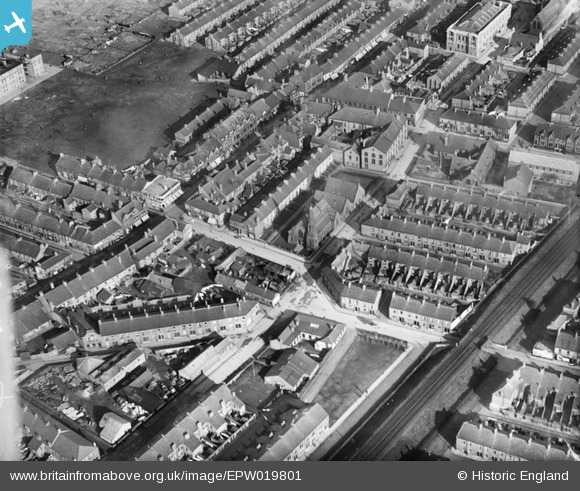
EPW019801 ENGLAND (1927). Warwick Road and the Presbyterian Church, Wallsend, 1927
© Copyright OpenStreetMap contributors and licensed by the OpenStreetMap Foundation. 2026. Cartography is licensed as CC BY-SA.
Details
| Title | [EPW019801] Warwick Road and the Presbyterian Church, Wallsend, 1927 |
| Reference | EPW019801 |
| Date | 20-October-1927 |
| Link | |
| Place name | WALLSEND |
| Parish | |
| District | |
| Country | ENGLAND |
| Easting / Northing | 429711, 566232 |
| Longitude / Latitude | -1.535609367449, 54.989716513958 |
| National Grid Reference | NZ297662 |
Pins

Bayardmm |
Wednesday 6th of April 2016 05:28:45 PM | |
|
andsome enery |
Sunday 20th of April 2014 05:39:54 PM | |
|
Geoff |
Monday 12th of August 2013 09:33:11 PM | |
alas, has now been demolished |
andsome enery |
Sunday 20th of April 2014 05:29:08 PM |
|
andsome enery |
Saturday 20th of October 2012 02:50:17 PM | |
|
Eric Hollerton |
Thursday 13th of September 2012 07:12:04 PM | |
There are also some details at www.ukniwm.org.uk/server/show/conMemorial.34506/fromUkniwmSearch/1. |

melgibbs |
Monday 30th of December 2013 07:04:52 PM |
|
Eric Hollerton |
Thursday 13th of September 2012 06:47:58 PM | |
|
Eric Hollerton |
Thursday 13th of September 2012 06:37:50 PM | |
|
Eric Hollerton |
Thursday 13th of September 2012 06:36:24 PM | |
|
Eric Hollerton |
Thursday 13th of September 2012 06:34:34 PM |

User Comment Contributions
Warwick Road runs across the view, roughly speaking from the bottom left towards the top right. Parallel, across the bottom right corner is part of the Newcastle to North Shields railway line (opened in 1839). Parallel to the left is High Street West. Portugal Place cuts across the east/west alignment of the main routes. It lies on the route of the Coxlodge Colliery waggonway, there before the area was built up. In the middle is St Andrew's Presbyterian Church. The Memorial Hall is in the top right. |
Eric Hollerton |
Thursday 13th of September 2012 06:27:12 PM |