
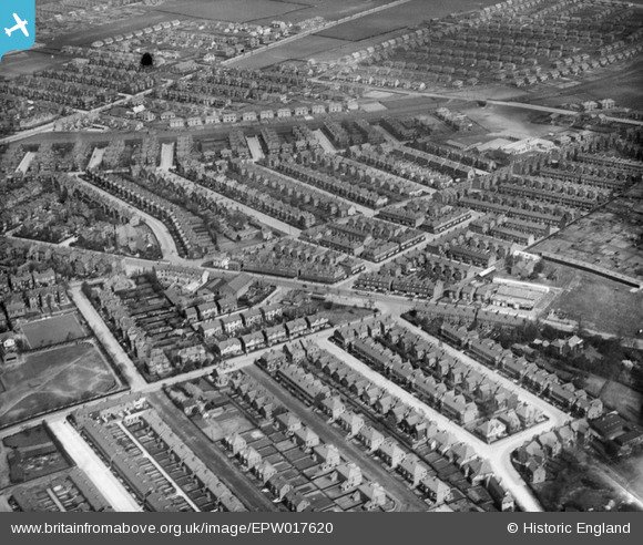
EPW017620 ENGLAND (1927). Sandy Lane and environs, Chorlton-cum-Hardy, 1927
© Copyright OpenStreetMap contributors and licensed by the OpenStreetMap Foundation. 2026. Cartography is licensed as CC BY-SA.
Details
| Title | [EPW017620] Sandy Lane and environs, Chorlton-cum-Hardy, 1927 |
| Reference | EPW017620 |
| Date | April-1927 |
| Link | |
| Place name | CHOLRTON-CUM-HARDY |
| Parish | |
| District | |
| Country | ENGLAND |
| Easting / Northing | 381915, 393505 |
| Longitude / Latitude | -2.2722695296811, 53.437754833976 |
| National Grid Reference | SJ819935 |
Pins

SSTIRLING1212 |
Thursday 11th of November 2021 02:14:49 PM | |
|
WardyHeritage |
Wednesday 14th of April 2021 02:32:07 PM | |
|
Mags |
Thursday 27th of February 2020 04:14:51 PM | |
|
Andrew |
Friday 14th of February 2020 12:32:23 PM | |
|
Andrew |
Friday 14th of February 2020 12:32:02 PM | |
|
Andrew |
Friday 14th of February 2020 12:31:12 PM | |
|
Andrew |
Friday 14th of February 2020 12:30:51 PM | |
|
Andrew |
Friday 14th of February 2020 12:30:29 PM | |
|
Richard |
Tuesday 22nd of August 2017 07:12:34 PM | |
|
Stretfordian |
Tuesday 17th of May 2016 12:43:59 AM | |
|
Matthew |
Thursday 22nd of May 2014 12:10:11 PM | |
|
Andrew |
Thursday 17th of October 2013 11:35:28 AM | |
|
Adam davison home |
Thursday 25th of April 2013 11:32:07 AM | |
|
GinnyC |
Sunday 31st of March 2013 10:50:47 PM | |
|
GinnyC |
Sunday 31st of March 2013 10:50:45 PM | |
|
John Ellis |
Saturday 3rd of November 2012 03:04:56 PM | |
|
MB |
Saturday 3rd of November 2012 01:37:48 PM | |
|
MB |
Saturday 3rd of November 2012 01:37:16 PM | |
|
John Ellis |
Saturday 3rd of November 2012 12:44:14 PM | |
|
John Ellis |
Saturday 3rd of November 2012 12:43:47 PM | |
|
John Ellis |
Saturday 3rd of November 2012 12:41:16 PM | |
|
John Ellis |
Saturday 3rd of November 2012 12:39:49 PM | |
|
John Ellis |
Saturday 3rd of November 2012 12:38:59 PM | |
|
John Ellis |
Saturday 3rd of November 2012 12:37:18 PM | |
|
John Ellis |
Saturday 3rd of November 2012 12:36:24 PM | |
|
John Ellis |
Saturday 3rd of November 2012 12:35:34 PM | |
|
John Ellis |
Saturday 3rd of November 2012 12:33:37 PM | |
|
John Ellis |
Saturday 3rd of November 2012 12:30:59 PM | |
|
John Ellis |
Saturday 3rd of November 2012 12:23:36 PM | |
|
John Ellis |
Wednesday 11th of July 2012 09:01:22 AM | |
|
John Ellis |
Wednesday 11th of July 2012 08:59:16 AM | |
|
John Ellis |
Wednesday 11th of July 2012 08:58:37 AM | |
|
John Ellis |
Wednesday 11th of July 2012 08:54:36 AM | |
|
John Ellis |
Wednesday 11th of July 2012 08:52:16 AM | |
|
John Ellis |
Wednesday 11th of July 2012 08:50:53 AM | |
|
John Ellis |
Tuesday 10th of July 2012 11:38:33 PM | |
|
John Ellis |
Tuesday 10th of July 2012 11:37:58 PM | |
Minor correction - went comprehensive in 1967 .. I was there |
John French |
Tuesday 7th of August 2012 10:26:19 PM |
Rebuke accepted - I was there too, but I'd left by then! I'd somehow got the impression that it didn't happen till the beginning of the '70s. |
John Ellis |
Thursday 23rd of August 2012 11:41:44 PM |
This shows the school before it was considerably enlarged in the 1930s. |
tony.g |
Wednesday 5th of June 2013 11:10:05 PM |
|
MWM |
Wednesday 4th of July 2012 09:47:59 PM | |
|
MWM |
Wednesday 4th of July 2012 09:36:41 PM |

User Comment Contributions
I got it wrong first time, mislead by the title. The road across the picture is Barlow Moor Rd continueing right to Chorlton Park and Southern Cemetary. The light blg was first a skating ring and became a dance Hall.Chorlton High/Grammar is towards the top of Sandy Lane running SW to NE of pic.The road from centre running to SW is Beech Road with what we knew as Chorlton Rec. almost off the picture. Confirmed the Grammar School demolished and moved to Nell Lane just off the picture. |
A T Green |
Monday 9th of July 2012 07:46:50 PM |
I think the light- coloured building half way up on the right-hand side is Chorlton High School - later to become Chorlton Grammar School & now demolished. Can anyone confirm? There is a photo of it here:- http://images.manchester.gov.uk/web/objects/common/webmedia.php?irn=51831&reftable=ecatalogue&refirn=53717 |
cgsob |
Tuesday 3rd of July 2012 10:37:56 PM |
I think the building that you refer to is now MC Donalds with the school further to the right and off the photo. I hope this helps? |
Simonster28 |
Tuesday 3rd of July 2012 10:37:56 PM |