
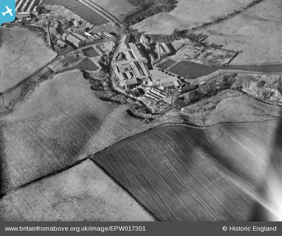
EPW017301 ENGLAND (1926). Thomas L. Livsey Hollins Vale Bleach Works, Hollins, 1926
© Copyright OpenStreetMap contributors and licensed by the OpenStreetMap Foundation. 2025. Cartography is licensed as CC BY-SA.
Details
| Title | [EPW017301] Thomas L. Livsey Hollins Vale Bleach Works, Hollins, 1926 |
| Reference | EPW017301 |
| Date | October-1926 |
| Link | |
| Place name | HOLLINS |
| Parish | |
| District | |
| Country | ENGLAND |
| Easting / Northing | 381633, 408376 |
| Longitude / Latitude | -2.2773863186264, 53.571425700847 |
| National Grid Reference | SD816084 |
Pins

Class31 |
Thursday 12th of July 2012 08:30:32 PM | |

BigglesH |
Monday 9th of July 2012 03:05:21 AM | |
Not a canal basin, the nearest canal is the Manchester, Bolton & Bury, which doesn't connect to this. The water is part of a series of reservoirs. |
parrot |
Monday 20th of May 2013 01:40:13 PM |
|
Tiny Tim |
Saturday 30th of June 2012 04:36:02 PM |
User Comment Contributions
The Hags, Hollins |
David |
Tuesday 23rd of October 2012 04:04:59 PM |
Hi David, That’s great; we’ve reviewed your identification and thanks to your help we can update the catalogue. The revised record with the correct location will appear here in due course. Top spot, thanks. Yours, Katy Britain from Above Cataloguing Team Leader |
Katy Whitaker |
Tuesday 23rd of October 2012 04:04:59 PM |
I agree with David. Much of the detail can be found on the recent Ordnance Survey map. The route of Hollins Brook is identical. The large water feature on the right of the shot is the same. The small rectangular pond on the left is present today although the large rectangular pond has disappeared. Today the triangular pond appears to have been partially or fully drained. The view is taken looking North West. |
Class31 |
Thursday 12th of July 2012 08:48:33 PM |
What sort of mill requires lots of water but not a lot of coal or bulky raw materials (which would need railway transport) |
BigglesH |
Monday 9th of July 2012 03:14:47 AM |