
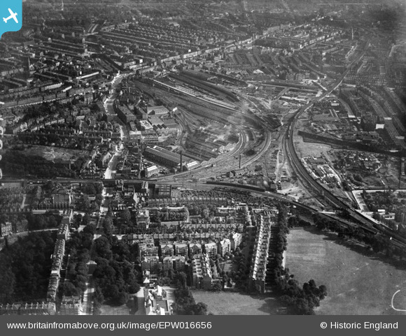
EPW016656 ENGLAND (1926). The Kentish Town Locomotive Sheds and environs, Gospel Oak, from the north-west, 1926
© Copyright OpenStreetMap contributors and licensed by the OpenStreetMap Foundation. 2026. Cartography is licensed as CC BY-SA.
Details
| Title | [EPW016656] The Kentish Town Locomotive Sheds and environs, Gospel Oak, from the north-west, 1926 |
| Reference | EPW016656 |
| Date | August-1926 |
| Link | |
| Place name | GOSPEL OAK |
| Parish | |
| District | |
| Country | ENGLAND |
| Easting / Northing | 528436, 185793 |
| Longitude / Latitude | -0.14715858674081, 51.555903785507 |
| National Grid Reference | TQ284858 |
Pins

PathFinder |
Sunday 12th of April 2026 07:50:59 PM | |
|
Robin |
Thursday 20th of February 2025 04:10:58 PM | |
|
Leslie B |
Friday 26th of August 2022 03:56:12 PM | |
|
Leslie B |
Friday 26th of August 2022 03:51:51 PM | |
|
Leslie B |
Friday 26th of August 2022 03:39:56 PM | |
|
Jim Corbett |
Saturday 6th of November 2021 08:30:42 AM | |
|
Jim Corbett |
Saturday 6th of November 2021 08:23:36 AM | |
|
Jim Corbett |
Saturday 6th of November 2021 08:21:04 AM | |
|
Jim Corbett |
Saturday 6th of November 2021 08:16:06 AM | |
|
Paul Wendon |
Tuesday 9th of March 2021 07:32:36 PM | |
|
Paul Wendon |
Tuesday 9th of March 2021 07:32:00 PM | |
|
Paul Wendon |
Tuesday 9th of March 2021 07:28:04 PM | |
|
Paul Wendon |
Tuesday 9th of March 2021 07:27:34 PM | |
|
Ted Maul |
Thursday 31st of October 2019 11:27:23 AM | |
|
Smudger |
Wednesday 10th of July 2019 08:46:39 PM | |
|
Leslie B |
Saturday 28th of October 2017 02:22:38 PM | |
|
David Posnett |
Saturday 15th of July 2017 09:57:14 AM | |
|
Leslie B |
Monday 4th of April 2016 07:51:03 PM | |
|
Leslie B |
Monday 4th of April 2016 06:19:13 PM | |
|
DesQ |
Saturday 4th of May 2013 01:10:28 PM | |
|
DesQ |
Saturday 4th of May 2013 12:40:45 PM | |
|
GLOMR7 |
Saturday 30th of June 2012 06:16:46 PM | |
|
etr220 |
Tuesday 26th of June 2012 06:58:36 PM | |
|
etr220 |
Tuesday 26th of June 2012 06:57:44 PM | |
all comments correct. I'm from Glasgow and even Isuspected the location. well done fellow railway buffs! |
dave |
Wednesday 4th of July 2012 12:20:09 AM |
User Comment Contributions
Hopefully the image immediately right will turn up as I'd love to see what was there before all the estates in that area. I lived in Vicars Road in the mid 1960's (until the age of 3) and have never seen a picture of that street or the house I lived in before the clearance. I notice the area where the estate Kiln Place is now. I wonder if they are brick kilns. |
scarymonster |
Sunday 27th of April 2014 12:06:11 PM |
The mansion blocks in the foreground are Lissenden Gardens, which had been built at the turn of the century and are still standing, apart from 1-10 which was destroyed in World War II |
DesQ |
Saturday 4th of May 2013 12:40:03 PM |
Dear etr220 and GLOMR7, That’s great; we’ve reviewed your comments and thanks to your help we can update the catalogue. The revised record will appear here in due course. Hope you have the same success solving some of our other mysteries! Katy Whitaker Britain from Above Cataloguer |
Katy Whitaker |
Monday 2nd of July 2012 03:14:49 PM |
View is looking SSE, Gospel Oak Station at the railway on the right hand side of picture, towards the bottom; and Kentish Town Station mid way between centre and top left corner |
etr220 |
Tuesday 26th of June 2012 06:58:52 PM |