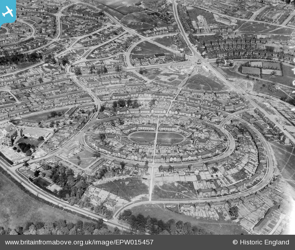
EPW015457 ENGLAND (1926). Firth Park, Sheffield, 1926
© Copyright OpenStreetMap contributors and licensed by the OpenStreetMap Foundation. 2026. Cartography is licensed as CC BY-SA.
Details
| Title | [EPW015457] Firth Park, Sheffield, 1926 |
| Reference | EPW015457 |
| Date | 4-May-1926 |
| Link | |
| Place name | SHEFFIELD |
| Parish | |
| District | |
| Country | ENGLAND |
| Easting / Northing | 436483, 391273 |
| Longitude / Latitude | -1.4510177317037, 53.41673868903 |
| National Grid Reference | SK365913 |
Pins

Marco1968 |
Sunday 7th of February 2021 01:34:23 PM | |

Class31 |
Friday 26th of October 2012 11:36:46 AM | |

Class31 |
Friday 26th of October 2012 11:36:18 AM | |

Class31 |
Friday 26th of October 2012 11:34:59 AM | |

Class31 |
Friday 26th of October 2012 11:34:07 AM | |

Class31 |
Friday 26th of October 2012 11:33:26 AM | |

Class31 |
Friday 26th of October 2012 11:33:03 AM | |

Class31 |
Friday 26th of October 2012 11:31:18 AM | |

Class31 |
Friday 26th of October 2012 11:30:44 AM | |

Class31 |
Friday 26th of October 2012 11:29:33 AM | |

Class31 |
Friday 26th of October 2012 11:28:56 AM | |

Class31 |
Friday 26th of October 2012 11:28:16 AM | |

Class31 |
Friday 26th of October 2012 11:27:37 AM | |

Class31 |
Friday 26th of October 2012 11:27:06 AM | |

Class31 |
Friday 26th of October 2012 11:26:29 AM | |

Class31 |
Friday 26th of October 2012 11:26:05 AM | |

Class31 |
Friday 26th of October 2012 11:25:24 AM | |

Class31 |
Friday 26th of October 2012 11:24:54 AM | |

bayleaf |
Saturday 4th of August 2012 03:40:20 PM | |

Shaunmac1966 |
Tuesday 17th of July 2012 12:48:01 AM | |

flubber |
Tuesday 3rd of July 2012 01:30:54 AM | |

flubber |
Tuesday 3rd of July 2012 01:29:50 AM | |

flubber |
Tuesday 3rd of July 2012 01:28:39 AM |

