
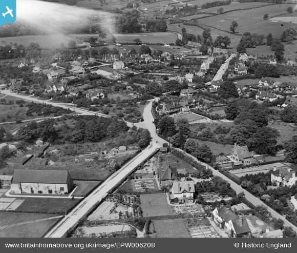
EPW006208 ENGLAND (1921). The junction of Austenwood Lane and Packhorse Road, Chalfont St Peter, 1921. This image has been affected by flare.
© Copyright OpenStreetMap contributors and licensed by the OpenStreetMap Foundation. 2025. Cartography is licensed as CC BY-SA.
Details
| Title | [EPW006208] The junction of Austenwood Lane and Packhorse Road, Chalfont St Peter, 1921. This image has been affected by flare. |
| Reference | EPW006208 |
| Date | April-1921 |
| Link | |
| Place name | CHALFONT ST PETER |
| Parish | CHALFONT ST. PETER |
| District | |
| Country | ENGLAND |
| Easting / Northing | 500122, 189635 |
| Longitude / Latitude | -0.55436649648899, 51.596179189999 |
| National Grid Reference | TQ001896 |
Pins

Ramblinjohn |
Thursday 5th of July 2012 09:26:18 PM | |
|
Ramblinjohn |
Thursday 5th of July 2012 09:16:23 PM | |
|
Ramblinjohn |
Thursday 5th of July 2012 09:02:59 PM | |
|
Ramblinjohn |
Thursday 5th of July 2012 09:01:56 PM | |
|
Ramblinjohn |
Thursday 5th of July 2012 09:01:22 PM | |
|
Ramblinjohn |
Thursday 5th of July 2012 09:00:34 PM | |
|
EastMarple1 |
Saturday 30th of June 2012 10:10:13 AM | |
Probably Chalfont St Peter's parish church? |
Ramblinjohn |
Thursday 5th of July 2012 09:12:19 PM |
|
EastMarple1 |
Saturday 30th of June 2012 10:03:35 AM | |
Barn not chapel, stable or other outhouse block to left end not consistent with chapel. Also not enough windows to be a chapel.... |
Jen |
Monday 2nd of July 2012 09:42:42 PM |
This is All Saints', Chalfont St Peter. http://www.csp-parish.org.uk/ |
Ramblinjohn |
Thursday 5th of July 2012 08:59:51 PM |
User Comment Contributions
This is Chalfont St Peter, Bucks. The grid ref for the junction where the two people are standing in the centre of the photo is approx TQ00138957. |
Ramblinjohn |
Tuesday 23rd of October 2012 01:12:37 PM |
Hi Ramblinjohn, That’s great; we’ve reviewed your comment and the subsequent annotations and thanks to your help we can update the catalogue. The revised record with the correct location will appear here in due course. Yours, Katy Britain from Above Cataloguing Team Leader |
Katy Whitaker |
Tuesday 23rd of October 2012 01:12:37 PM |
This is the junction of Austenwood Lane (10 o'clock), Kingsway (1 o'clock), Oval Way (7 o'clock) and Packhorse Lane (5 o'clock), looking due north and about 1 mile north of Gerrard's Cross. Chalfont St Peter dead ahead, Gold Hill just off the top left of the picture. The church on the left is All Saint's Chalfont St Peter, opened a few years before this photo was taken. |
H Howard |
Thursday 16th of August 2012 05:24:55 PM |
Junction between Oval Way/Packhorse Road/Austenwood Lane - Gerrards Cross/Chalfont St Peter. Thorpe House (1922/23) and Kingscote School (1965)are not yet built. |
Alfa |
Monday 9th of July 2012 11:49:50 PM |
Affluent area - commuter belt? Lots of large houses, gardens well tended. |
EastMarple1 |
Saturday 30th of June 2012 10:06:56 AM |