
EPW001710 ENGLAND (1920). Station Road and environs, Thames Ditton, 1920
© Copyright OpenStreetMap contributors and licensed by the OpenStreetMap Foundation. 2026. Cartography is licensed as CC BY-SA.
Details
| Title | [EPW001710] Station Road and environs, Thames Ditton, 1920 |
| Reference | EPW001710 |
| Date | June-1920 |
| Link | |
| Place name | THAMES DITTON |
| Parish | |
| District | |
| Country | ENGLAND |
| Easting / Northing | 515830, 166876 |
| Longitude / Latitude | -0.33513018986055, 51.388593821089 |
| National Grid Reference | TQ158669 |
Pins

KiwiMike |
Monday 24th of October 2016 10:28:29 PM | |

Jon |
Sunday 28th of October 2012 07:56:17 PM | |
The AC car factory is now the Harvest Lane gated estate built, I think, in 1987/8 or theresabout. It comprises 47 2,3 and 4-bedroom homes built over eight terrace blocks. |
KiwiMike |
Monday 24th of October 2016 09:59:43 PM |
|
Graham |
Monday 3rd of September 2012 10:19:26 PM | |
|
Graham |
Monday 3rd of September 2012 10:11:04 PM | |
|
Graham |
Monday 3rd of September 2012 09:49:07 PM | |
|
Graham |
Monday 3rd of September 2012 09:39:11 PM | |
|
Graham |
Monday 3rd of September 2012 09:34:42 PM | |
Norman origins. http://www.stnicholaschurch.org.uk/about-history.html |
KiwiMike |
Monday 24th of October 2016 10:06:24 PM |

Class31 |
Tuesday 7th of August 2012 05:21:26 PM | |
This House was Basing House situated in Watts Road, with grounds behind given over to new housing in Basing way and Basing Drive. Later (1950's?) more of Basing House grounds were sold of to housing development despite a covenent from sellers( Mr and Mrs Emsworth) that remaining grounds should be left intact as part of Basing House. |
Ronald |
Friday 14th of February 2014 02:39:03 PM |
|
Class31 |
Tuesday 7th of August 2012 05:12:26 PM | |
|
Dave Brunt |
Tuesday 7th of August 2012 04:04:18 PM | |
|
SteveAUS |
Thursday 5th of July 2012 06:45:44 AM | |
Maybe haymaking? |
SteveP |
Thursday 5th of July 2012 07:31:32 AM |
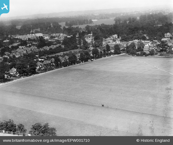
Hi SteveAUS, The horse and boy makes it look like ploughing, but the ground doesn't appear to be turned over so perhaps the grass is being cut or scoured - on the historical Ordnance Survey mapping this is an open area of ground with the footpath running through, but no labelling to give a park name, field name or to indicate allotments, for example. Yours, Katy Britain from Above Cataloguing Team Leader |
Katy Whitaker |
Wednesday 5th of September 2012 10:47:16 AM |
That's really interesting nutmeg. Maybe the landowner (which could have been the local authority I guess, in this built-up area) executed their responsibility for grass cutting by making hay! Yours, Katy |
Katy Whitaker |
Friday 28th of June 2013 01:32:58 PM |
This area would still have been agricultural in 1920 - compare earlier OS maps. I expect it was part of nearby Manor Farm (technically Weston Manor Farm) which was on the other side of the railway at bottom of photo. The last remnant of Manor Farm was still being worked as a farm (I remember cattle) in the 1950s, before being sold for school sports fields etc. There was much controversy about demolition of its medieval house and barns in the early 1960s. My mother (born 1908) remembered cornfields on Station Rd in her youth (earlier I wrote that it was hayfields before checking my facts - but the crop could change). This is probably haymaking as the photo was taken in June. On examining field more closely it looks as if the man with the horse is turning the hay to dry it, as he has left a darker line behind him. This is not bare earth as the soil of footpath cutting through the field is a different colour. |
nutmeg |
Sunday 30th of June 2013 03:15:33 PM |
|
EastMarple1 |
Saturday 30th of June 2012 10:55:52 AM | |
There is not a train line here. |
Graham |
Monday 3rd of September 2012 10:13:31 PM |
Either Summer Road, or the river Thames. |
Jon |
Sunday 28th of October 2012 08:04:16 PM |
Towpath and bank on opposite side of Thames. |
nutmeg |
Sunday 30th of June 2013 05:47:59 AM |
|
EastMarple1 |
Saturday 30th of June 2012 10:54:33 AM | |
There is not a railway line here. |
Graham |
Monday 3rd of September 2012 10:14:33 PM |
... and never was! |
KiwiMike |
Monday 24th of October 2016 09:51:45 PM |
|
EastMarple1 |
Saturday 30th of June 2012 10:51:22 AM | |
St. Nicholas' Church |
Class31 |
Tuesday 7th of August 2012 05:10:40 PM |
St Nicholas'Church indeed. Norman origins. http://www.stnicholaschurch.org.uk/about-history.html |
KiwiMike |
Monday 24th of October 2016 10:05:48 PM |
|
EastMarple1 |
Saturday 30th of June 2012 10:49:45 AM | |
Boyle Farm Stables [Home of Compassion} |
Dave Brunt |
Tuesday 7th of August 2012 04:01:50 PM |
clock and bell tower on Home of Compassion chapel |
D Mallett |
Sunday 2nd of June 2013 05:50:46 PM |
|
EastMarple1 |
Saturday 30th of June 2012 10:48:01 AM | |
This may have been a pub once but I think it is the building occupied by Wine Rack on Streetmap. |
Graham |
Monday 3rd of September 2012 10:16:29 PM |
The "George and Dragon" PH is located just east of the junction of Watts Road, Station Road, and the High Street. |
Jon |
Sunday 28th of October 2012 08:01:13 PM |
|
TonyW1960 |
Friday 29th of June 2012 10:12:51 PM | |
Thames Ditton Station |
Dave Brunt |
Tuesday 7th of August 2012 04:02:22 PM |
User Comment Contributions
The diagonal footpath is roughly along the current alignment of what is now Basing Way, coming off Station Road near the Manor House - the field is shown as "Basing Field" on the 1843 Tithe map and apportionment. The railway station and line to Hampton Court is off to to the left of the picture, with just a bit of the 'up' platform just being visible at the bottom of the image. Basingfield Road runs roughly along the track alignment running left to right along which the horse is moving. The A.C. Cars factory is also visible in the village centre. |
Jon |
Sunday 28th of October 2012 07:55:09 PM |