
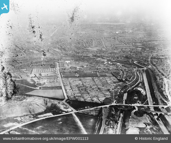
EPW001113 ENGLAND (1920). Allotments and Lewisham Park, Sandwell, from the north-west, 1920
© Copyright OpenStreetMap contributors and licensed by the OpenStreetMap Foundation. 2026. Cartography is licensed as CC BY-SA.
Details
| Title | [EPW001113] Allotments and Lewisham Park, Sandwell, from the north-west, 1920 |
| Reference | EPW001113 |
| Date | May-1920 |
| Link | |
| Place name | SANDWELL |
| Parish | |
| District | |
| Country | ENGLAND |
| Easting / Northing | 401718, 289512 |
| Longitude / Latitude | -1.9746875376789, 52.503138014652 |
| National Grid Reference | SP017895 |
Pins

Class31 |
Thursday 27th of August 2015 08:12:42 PM | |

Martin |
Monday 31st of March 2014 09:17:13 PM | |
|
Martin |
Monday 31st of March 2014 09:16:13 PM | |
|
Martin |
Monday 31st of March 2014 08:54:20 PM | |
|
Martin |
Monday 31st of March 2014 08:47:38 PM | |
|
Martin |
Monday 31st of March 2014 08:46:27 PM | |
|
Martin |
Monday 31st of March 2014 08:46:00 PM | |
|
Martin |
Monday 31st of March 2014 08:44:28 PM | |
|
Martin |
Monday 31st of March 2014 08:43:41 PM | |
|
Martin |
Monday 31st of March 2014 08:38:56 PM | |
|
Martin |
Monday 31st of March 2014 08:38:00 PM | |
|
Martin |
Monday 31st of March 2014 08:36:19 PM | |
|
Martin |
Monday 31st of March 2014 08:34:32 PM | |
|
Martin |
Monday 31st of March 2014 08:32:28 PM | |
|
artscotak2 |
Friday 20th of December 2013 02:11:25 PM | |
|
artscotak2 |
Friday 20th of December 2013 02:10:38 PM | |
|
artscotak2 |
Saturday 16th of March 2013 06:44:52 PM | |
now used as part of Smethwich Galton Bridge station |
Martin |
Monday 31st of March 2014 08:33:37 PM |
|
scoop115 |
Saturday 7th of July 2012 08:34:11 PM | |
|
artscotak2 |
Saturday 7th of July 2012 02:57:49 PM | |
|
artscotak2 |
Saturday 7th of July 2012 09:52:26 AM | |
|
Steve Cemm |
Friday 6th of July 2012 04:10:20 PM | |
|
rocky |
Thursday 28th of June 2012 10:00:17 PM | |
|
Steve Cemm |
Wednesday 27th of June 2012 04:03:29 PM | |
No. Its Galton Bridge. |
orkneystu |
Thursday 28th of June 2012 08:01:47 PM |
|
Steve Cemm |
Wednesday 27th of June 2012 04:02:35 PM |
User Comment Contributions
The view is from just west (Blackcountry or Oldbury) side of the Galton Bridge in Roebuck Lane looking towards the centre of Smethwick and Birmingham. |
orkneystu |
Thursday 5th of July 2012 08:51:47 PM |
Dear orkneystu, That’s great; we’ve reviewed your comments and thanks to your help we can update the catalogue. The revised record will appear here in due course. Hope you have the same success solving some of our other mysteries! Katy Whitaker Britain from Above Cataloguer |
Katy Whitaker |
Monday 2nd of July 2012 12:47:14 PM |
Confirmed. The road running up the middle of the photo is Dartmouth Road - Up until the 70's the heart of the Birmid Group of Foundries |
scoop115 |
Thursday 5th of July 2012 08:51:47 PM |