
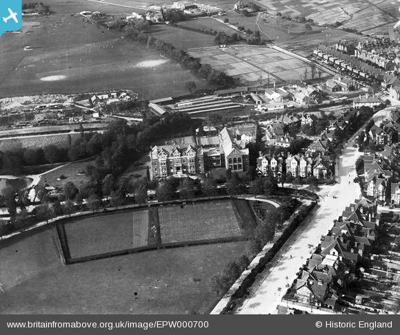
EPW000700 ENGLAND (1920). Victoria Hospital, Folkestone, 1920
© Copyright OpenStreetMap contributors and licensed by the OpenStreetMap Foundation. 2026. Cartography is licensed as CC BY-SA.
Details
| Title | [EPW000700] Victoria Hospital, Folkestone, 1920 |
| Reference | EPW000700 |
| Date | April-1920 |
| Link | |
| Place name | FOLKESTONE |
| Parish | FOLKESTONE |
| District | |
| Country | ENGLAND |
| Easting / Northing | 622253, 136629 |
| Longitude / Latitude | 1.1738376573692, 51.085319394478 |
| National Grid Reference | TR223366 |
Pins

Jumper_downunder |
Thursday 13th of June 2019 03:42:20 AM | |
|
Brian |
Monday 13th of August 2012 05:32:20 PM | |
|
Paolo |
Monday 6th of August 2012 04:41:45 PM | |
|
Paolo |
Friday 6th of July 2012 09:40:11 PM | |
|
Paolo |
Friday 6th of July 2012 09:38:40 PM | |
|
Paolo |
Friday 6th of July 2012 09:37:14 PM | |
|
Paolo |
Tuesday 3rd of July 2012 06:03:09 PM |
User Comment Contributions
Why does this say "Unlocated", when it is very clearly located in Folkestone? |
Nicholas Reed |
Tuesday 23rd of October 2012 09:29:15 AM |
Hi Nicholas, In answer to your question, we allow plenty of time for website users to view Unlocated images and comment on them. Although sometimes someone is able to identify a location very quickly, it is often the case that it takes a discussion about the location to finally fix on an answer. It also helps to have extra information - for example, a group of pins on the image indicating the relevant road names and buildings, or comments explaining features in the photo. For this image, the identification is correct and the information about the roads and buildings is really useful. Thanks to everyone's help we can update the catalogue, and the revised record will appear here in due course. This means that instead of "Unlocated", the image will have a caption, and we'll confirm the twelve figure grid-reference. Yours, Katy Britain from Above Cataloguing Team Leader |
Katy Whitaker |
Tuesday 23rd of October 2012 09:29:15 AM |
In front of the Hospital (the big building in the middle) is a field (?tennis court), which is now part of Radnor Park. The big road to the right is Radnor Park Road. The blue dot at far right is now the fire station at the start of Park Farm Road. First time I've done any of this identification! I now see that "Paulo" has identified most of these correctly. |
Nicholas Reed |
Saturday 20th of October 2012 07:24:16 AM |
Does anybody have an idea as to the purpose of the buildings behind the Hospital, on the other side of the Pent Stream. Could it be a council depot with nurseries adjacent? |
Paolo |
Wednesday 10th of October 2012 07:09:40 PM |