
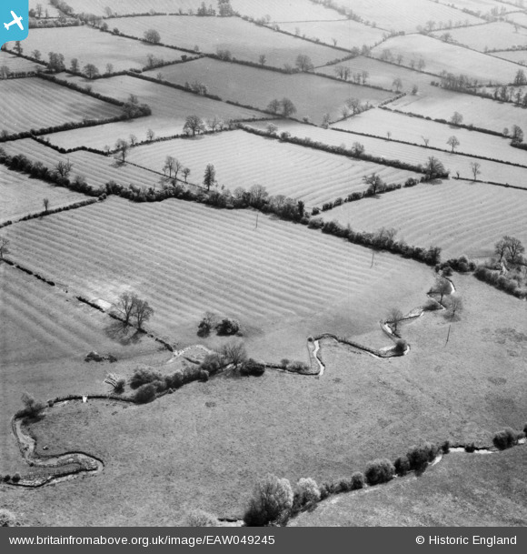
EAW049245 ENGLAND (1953). Ridge and furrow near the River Dikler, Wyck Rissington, 1953
© Copyright OpenStreetMap contributors and licensed by the OpenStreetMap Foundation. 2026. Cartography is licensed as CC BY-SA.
Details
| Title | [EAW049245] Ridge and furrow near the River Dikler, Wyck Rissington, 1953 |
| Reference | EAW049245 |
| Date | 12-May-1953 |
| Link | |
| Place name | WYCK RISSINGTON |
| Parish | WICK RISSINGTON |
| District | |
| Country | ENGLAND |
| Easting / Northing | 418142, 221042 |
| Longitude / Latitude | -1.736370552077, 51.887201396305 |
| National Grid Reference | SP181210 |
Pins
 The clear meadow area in the lowest part of this photograph sits between the River Dikler and the River Eye, on the eastern edge of the village of Bourton-on-the-Water, Gloucestershire. The camera is facing south-east. The River Eye is closest to the camera, running south, from the centre of the lower edge of the photograph, to the right-hand edge. The River Dikler has the more obvious bends, running from the lower left-hand corner of the photograph. These two small rivers join together just off the right-hand edge of the photograph.
This particular area is fairly easy to identify due to the distinctive bends pictured in the River Dikler, using an Ordnance Survey 1:25 000 map or similar, or Google Maps.
The meadow berween the two rivers is no longer clear and open, having been planted with mixed conifer and deciduous trees since the photo was taken. Consequently, the distinctive bends in the River Dikler are difficult to identify in modern aerial images (e.g. Google Maps satellite images), due to the vegetation cover. However, on plain maps these river bends are clear to see.
The ridge and furrow features in the fore and mid-ground have since been lost to modern farm ploughing. Many of the field boundaries shown have also now disappeared, due to consolidation of the fields into larger units.
For those wishing to confirm the area of this photograph, the pin marker in the meadow between the two rivers is centred on the following geographic references:
UK Grid Reference: SP18000 21106
UK Grid Reference (6 figure): SP180211
X (Easting) ,Y (Northing): 418000, 221106
Latitude, Longitude (decimal): 51.888223 ,-1.739863
Latitude, Longitude (degs, mins, secs): 51°53'18"N , 001°4424"W
What3Words: squabbles.opinion.bitters The clear meadow area in the lowest part of this photograph sits between the River Dikler and the River Eye, on the eastern edge of the village of Bourton-on-the-Water, Gloucestershire. The camera is facing south-east. The River Eye is closest to the camera, running south, from the centre of the lower edge of the photograph, to the right-hand edge. The River Dikler has the more obvious bends, running from the lower left-hand corner of the photograph. These two small rivers join together just off the right-hand edge of the photograph.
This particular area is fairly easy to identify due to the distinctive bends pictured in the River Dikler, using an Ordnance Survey 1:25 000 map or similar, or Google Maps.
The meadow berween the two rivers is no longer clear and open, having been planted with mixed conifer and deciduous trees since the photo was taken. Consequently, the distinctive bends in the River Dikler are difficult to identify in modern aerial images (e.g. Google Maps satellite images), due to the vegetation cover. However, on plain maps these river bends are clear to see.
The ridge and furrow features in the fore and mid-ground have since been lost to modern farm ploughing. Many of the field boundaries shown have also now disappeared, due to consolidation of the fields into larger units.
For those wishing to confirm the area of this photograph, the pin marker in the meadow between the two rivers is centred on the following geographic references:
UK Grid Reference: SP18000 21106
UK Grid Reference (6 figure): SP180211
X (Easting) ,Y (Northing): 418000, 221106
Latitude, Longitude (decimal): 51.888223 ,-1.739863
Latitude, Longitude (degs, mins, secs): 51°53'18"N , 001°4424"W
What3Words: squabbles.opinion.bitters |

bernoullis |
Thursday 3rd of September 2026 12:29:46 PM |