
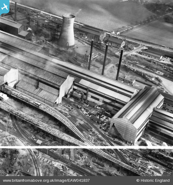
EAW041837 ENGLAND (1952). Part of the John Lysaght Normanby Park Steel Works, Scunthorpe, 1952. This image has been produced from a print marked by Aerofilms Ltd for photo editing.
© Copyright OpenStreetMap contributors and licensed by the OpenStreetMap Foundation. 2026. Cartography is licensed as CC BY-SA.
Nearby Images (48)
EAW041834

EAW031179

EAW041836

EAW041833

EAW009623

EAW016665

EAW019665

EAW049664

EAW034820

EAW041835

EAW034798

EAW009627

EAW041829

EAW031171

EAW038747

EAW034803

EAW021140

EAW038769

EAW016663

EAW038768

EAW021129

EAW034825

EAW041831

EAW013494

EAW009413

EAW049667

EAW034807

EAW031169

EAW009414

EAW027167

EAW016666

EAW021141
, Scunthorpe, 1949. This image has been produced from a damaged negative.")
EAW013496

EAW023920

EAW038760

EAW013491

EAW009639

EAW038764

EAW041844

EAW034802

EAW041842

EAW041840

EAW038763

EAW041843

EAW041841

EAW041839

EAW019677

EAW034826

Details
| Title | [EAW041837] Part of the John Lysaght Normanby Park Steel Works, Scunthorpe, 1952. This image has been produced from a print marked by Aerofilms Ltd for photo editing. |
| Reference | EAW041837 |
| Date | 10-March-1952 |
| Link | |
| Place name | SCUNTHORPE |
| Parish | |
| District | |
| Country | ENGLAND |
| Easting / Northing | 488959, 413419 |
| Longitude / Latitude | -0.65525906597775, 53.609525537348 |
| National Grid Reference | SE890134 |
Pins
Be the first to add a comment to this image!