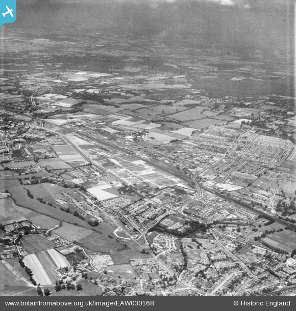
EAW030168 ENGLAND (1950). The Slough Trading Estate and environs, Slough, from the south-east, 1950
© Copyright OpenStreetMap contributors and licensed by the OpenStreetMap Foundation. 2026. Cartography is licensed as CC BY-SA.
Details
| Title | [EAW030168] The Slough Trading Estate and environs, Slough, from the south-east, 1950 |
| Reference | EAW030168 |
| Date | 5-June-1950 |
| Link | |
| Place name | SLOUGH |
| Parish | |
| District | |
| Country | ENGLAND |
| Easting / Northing | 496097, 180289 |
| Longitude / Latitude | -0.61501810448497, 51.512861827282 |
| National Grid Reference | SU961803 |
Pins

designking |
Tuesday 6th of August 2024 10:04:10 PM | |

designking |
Tuesday 6th of August 2024 09:47:48 PM | |

designking |
Tuesday 6th of August 2024 09:46:52 PM | |

designking |
Tuesday 6th of August 2024 09:44:47 PM | |

designking |
Tuesday 6th of August 2024 09:40:45 PM | |

designking |
Friday 11th of December 2020 07:59:08 PM | |

Mary Haskell |
Thursday 1st of November 2018 08:58:38 PM | |

Mike Holder |
Friday 2nd of February 2018 06:30:16 PM | |

Mike Holder |
Friday 2nd of February 2018 06:29:49 PM | |

Mike Holder |
Friday 2nd of February 2018 06:27:56 PM | |

Mike Holder |
Friday 2nd of February 2018 06:26:54 PM | |

Mike Holder |
Friday 2nd of February 2018 06:25:20 PM | |

Mike Holder |
Friday 2nd of February 2018 06:23:06 PM | |

Mike Gerrish |
Saturday 27th of January 2018 11:26:45 AM | |

dave43 |
Friday 25th of April 2014 08:42:22 PM | |

dave43 |
Friday 25th of April 2014 08:39:28 PM | |

dave43 |
Friday 25th of April 2014 08:36:34 PM | |

dave43 |
Friday 25th of April 2014 08:32:17 PM | |

dave43 |
Friday 25th of April 2014 08:30:52 PM | |
It was used by the Army during WW2, they had Tanks and Trucks there to protect the Trading Estate. |

fulham rebel |
Thursday 5th of February 2015 10:06:23 PM |

dave43 |
Friday 25th of April 2014 08:28:45 PM | |

dave43 |
Friday 25th of April 2014 08:26:30 PM | |

dave43 |
Friday 25th of April 2014 08:25:34 PM | |

dave43 |
Friday 25th of April 2014 08:19:51 PM | |

dave43 |
Friday 25th of April 2014 08:10:02 PM | |

dave43 |
Friday 25th of April 2014 08:08:16 PM | |

dave43 |
Friday 25th of April 2014 08:06:37 PM | |

dave43 |
Friday 25th of April 2014 08:01:26 PM | |

dave43 |
Friday 25th of April 2014 07:59:30 PM | |

dave43 |
Friday 25th of April 2014 07:58:20 PM | |

dave43 |
Friday 25th of April 2014 07:56:36 PM | |

dave43 |
Friday 25th of April 2014 07:53:09 PM |

