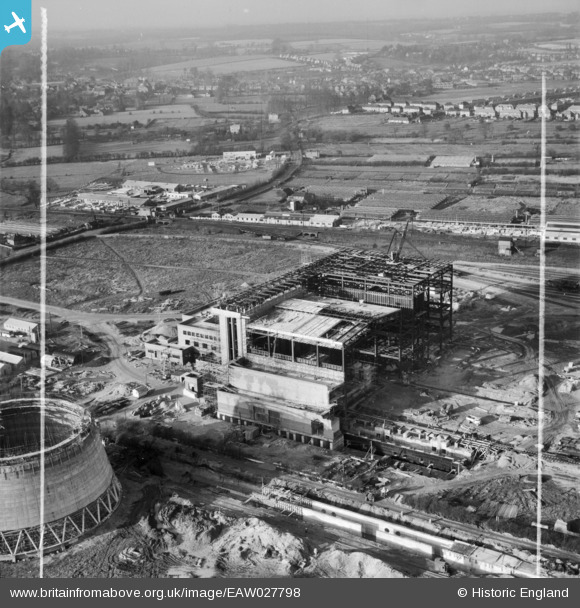
EAW027798 ENGLAND (1949). Rye House Power Station under construction, Rye Park, 1949. This image was marked by Aerofilms Ltd for photo editing.
© Copyright OpenStreetMap contributors and licensed by the OpenStreetMap Foundation. 2025. Cartography is licensed as CC BY-SA.
Nearby Images (48)
Details
| Title | [EAW027798] Rye House Power Station under construction, Rye Park, 1949. This image was marked by Aerofilms Ltd for photo editing. |
| Reference | EAW027798 |
| Date | 19-December-1949 |
| Link | |
| Place name | RYE PARK |
| Parish | |
| District | |
| Country | ENGLAND |
| Easting / Northing | 538586, 208838 |
| Longitude / Latitude | 0.0083116171037495, 51.760601178128 |
| National Grid Reference | TL386088 |
Pins
Be the first to add a comment to this image!


![[EAW026274] Rye House Power Station under construction, Rye Park, 1949](http://britainfromabove.org.uk/sites/all/libraries/aerofilms-images/public/100x100/EAW/026/EAW026274.jpg)
![[EAW040607] Rye House Power Station under construction, Rye Park, 1951](http://britainfromabove.org.uk/sites/all/libraries/aerofilms-images/public/100x100/EAW/040/EAW040607.jpg)
![[EAW040615] Rye House Power Station under construction, Rye Park, 1951](http://britainfromabove.org.uk/sites/all/libraries/aerofilms-images/public/100x100/EAW/040/EAW040615.jpg)
![[EAW036394] Rye House Power Station under construction, Rye Park, 1951. This image has been produced from a print marked by Aerofilms Ltd for photo editing.](http://britainfromabove.org.uk/sites/all/libraries/aerofilms-images/public/100x100/EAW/036/EAW036394.jpg)
![[EAW047235] Rye House Power Station, Hoddesdon, 1952](http://britainfromabove.org.uk/sites/all/libraries/aerofilms-images/public/100x100/EAW/047/EAW047235.jpg)
![[EAW032357] Rye House Power Station under construction, Rye Park, 1950. This image was marked by Aerofilms Ltd for photo editing.](http://britainfromabove.org.uk/sites/all/libraries/aerofilms-images/public/100x100/EAW/032/EAW032357.jpg)
![[EAW034502] Rye House Power Station under construction, Rye Park, 1951. This image has been produced from a print marked by Aerofilms Ltd for photo editing.](http://britainfromabove.org.uk/sites/all/libraries/aerofilms-images/public/100x100/EAW/034/EAW034502.jpg)
![[EAW027797] Rye House Power Station under construction, Rye Park, 1949. This image was marked by Aerofilms Ltd for photo editing.](http://britainfromabove.org.uk/sites/all/libraries/aerofilms-images/public/100x100/EAW/027/EAW027797.jpg)
![[EAW042020] Rye House Power Station under construction, Rye Park, 1952. This image has been produced from a print.](http://britainfromabove.org.uk/sites/all/libraries/aerofilms-images/public/100x100/EAW/042/EAW042020.jpg)
![[EAW047236] Rye House Power Station, Hoddesdon, 1952](http://britainfromabove.org.uk/sites/all/libraries/aerofilms-images/public/100x100/EAW/047/EAW047236.jpg)
![[EAW047246] Rye House Power Station, Hoddesdon, 1952](http://britainfromabove.org.uk/sites/all/libraries/aerofilms-images/public/100x100/EAW/047/EAW047246.jpg)
![[EAW026275] Rye House Power Station under construction, Rye Park, 1949](http://britainfromabove.org.uk/sites/all/libraries/aerofilms-images/public/100x100/EAW/026/EAW026275.jpg)
![[EAW028689] Rye House Power Station under construction, Rye Park, from the north-west, 1950](http://britainfromabove.org.uk/sites/all/libraries/aerofilms-images/public/100x100/EAW/028/EAW028689.jpg)
![[EAW034498] Rye House Power Station under construction, Rye Park, 1951. This image has been produced from a print marked by Aerofilms Ltd for photo editing.](http://britainfromabove.org.uk/sites/all/libraries/aerofilms-images/public/100x100/EAW/034/EAW034498.jpg)
![[EAW034500] Rye House Power Station under construction, Rye Park, 1951. This image has been produced from a print marked by Aerofilms Ltd for photo editing.](http://britainfromabove.org.uk/sites/all/libraries/aerofilms-images/public/100x100/EAW/034/EAW034500.jpg)
![[EAW036382] Rye House Power Station under construction, Rye Park, 1951. This image has been produced from a print marked by Aerofilms Ltd for photo editing.](http://britainfromabove.org.uk/sites/all/libraries/aerofilms-images/public/100x100/EAW/036/EAW036382.jpg)
![[EAW026282] Rye House Power Station under construction, Rye Park, 1949. This image has been produced from a print.](http://britainfromabove.org.uk/sites/all/libraries/aerofilms-images/public/100x100/EAW/026/EAW026282.jpg)
![[EAW040604] Rye House Power Station under construction, Rye Park, 1951](http://britainfromabove.org.uk/sites/all/libraries/aerofilms-images/public/100x100/EAW/040/EAW040604.jpg)
![[EAW040609] Rye House Power Station under construction, Rye Park, 1951](http://britainfromabove.org.uk/sites/all/libraries/aerofilms-images/public/100x100/EAW/040/EAW040609.jpg)
![[EAW022411] Rye House Power Station under construction, Rye Park, 1949](http://britainfromabove.org.uk/sites/all/libraries/aerofilms-images/public/100x100/EAW/022/EAW022411.jpg)
![[EAW034496] Rye House Power Station under construction, Rye Park, 1951. This image has been produced from a print marked by Aerofilms Ltd for photo editing.](http://britainfromabove.org.uk/sites/all/libraries/aerofilms-images/public/100x100/EAW/034/EAW034496.jpg)
![[EAW036379] Rye House Power Station under construction, Rye Park, 1951. This image has been produced from a print marked by Aerofilms Ltd for photo editing.](http://britainfromabove.org.uk/sites/all/libraries/aerofilms-images/public/100x100/EAW/036/EAW036379.jpg)
![[EAW040610] Rye House Power Station under construction, Rye Park, 1951](http://britainfromabove.org.uk/sites/all/libraries/aerofilms-images/public/100x100/EAW/040/EAW040610.jpg)
![[EAW040614] Rye House Power Station under construction, Rye Park, 1951](http://britainfromabove.org.uk/sites/all/libraries/aerofilms-images/public/100x100/EAW/040/EAW040614.jpg)
![[EAW050614] Rye House Power Station, Rye Park, from the south-west, 1953](http://britainfromabove.org.uk/sites/all/libraries/aerofilms-images/public/100x100/EAW/050/EAW050614.jpg)
![[EAW032360] Rye House Power Station under construction, Rye Park, 1950](http://britainfromabove.org.uk/sites/all/libraries/aerofilms-images/public/100x100/EAW/032/EAW032360.jpg)
![[EAW040618] Rye House Power Station under construction, Rye Park, 1951](http://britainfromabove.org.uk/sites/all/libraries/aerofilms-images/public/100x100/EAW/040/EAW040618.jpg)
![[EAW053094] Rye House Power Station, Rye Park, 1954](http://britainfromabove.org.uk/sites/all/libraries/aerofilms-images/public/100x100/EAW/053/EAW053094.jpg)
![[EAW042018] Rye House Power Station and environs, Rye Park, 1952](http://britainfromabove.org.uk/sites/all/libraries/aerofilms-images/public/100x100/EAW/042/EAW042018.jpg)
![[EAW032354] Rye House Power Station under construction, Rye Park, 1950](http://britainfromabove.org.uk/sites/all/libraries/aerofilms-images/public/100x100/EAW/032/EAW032354.jpg)
![[EAW032359] Rye House Power Station under construction, Rye Park, 1950](http://britainfromabove.org.uk/sites/all/libraries/aerofilms-images/public/100x100/EAW/032/EAW032359.jpg)
![[EAW027802] Rye House Power Station under construction, Rye Park, from the north-west, 1949. This image was marked by Aerofilms Ltd for photo editing.](http://britainfromabove.org.uk/sites/all/libraries/aerofilms-images/public/100x100/EAW/027/EAW027802.jpg)
![[EAW040605] Rye House Power Station under construction, Rye Park, 1951](http://britainfromabove.org.uk/sites/all/libraries/aerofilms-images/public/100x100/EAW/040/EAW040605.jpg)
![[EAW040606] Rye House Power Station under construction, Rye Park, 1951](http://britainfromabove.org.uk/sites/all/libraries/aerofilms-images/public/100x100/EAW/040/EAW040606.jpg)
![[EAW022414] Rye House Power Station under construction, Rye Park, 1949](http://britainfromabove.org.uk/sites/all/libraries/aerofilms-images/public/100x100/EAW/022/EAW022414.jpg)
![[EAW036395] Rye House Power Station under construction, Rye Park, 1951. This image has been produced from a print marked by Aerofilms Ltd for photo editing.](http://britainfromabove.org.uk/sites/all/libraries/aerofilms-images/public/100x100/EAW/036/EAW036395.jpg)
![[EAW032358] Rye House Power Station under construction, Rye Park, 1950. This image was marked by Aerofilms Ltd for photo editing.](http://britainfromabove.org.uk/sites/all/libraries/aerofilms-images/public/100x100/EAW/032/EAW032358.jpg)
![[EAW042025] Rye House Power Station under construction, Rye Park, 1952. This image has been produced from a print.](http://britainfromabove.org.uk/sites/all/libraries/aerofilms-images/public/100x100/EAW/042/EAW042025.jpg)
![[EAW053076] Rye House Power Station, Hoddesdon, from the west, 1954](http://britainfromabove.org.uk/sites/all/libraries/aerofilms-images/public/100x100/EAW/053/EAW053076.jpg)
![[EAW028700] Rye House Power Station under construction, Rye Park, from the south-west, 1950. This image was marked by Aerofilms Ltd for photo editing.](http://britainfromabove.org.uk/sites/all/libraries/aerofilms-images/public/100x100/EAW/028/EAW028700.jpg)
![[EAW032361] Rye House Power Station under construction, Rye Park, 1950. This image was marked by Aerofilms Ltd for photo editing.](http://britainfromabove.org.uk/sites/all/libraries/aerofilms-images/public/100x100/EAW/032/EAW032361.jpg)
![[EAW036381] Rye House Power Station under construction, Rye Park, from the north-west, 1951. This image has been produced from a print marked by Aerofilms Ltd for photo editing.](http://britainfromabove.org.uk/sites/all/libraries/aerofilms-images/public/100x100/EAW/036/EAW036381.jpg)
![[EAW028693] Rye House Power Station under construction, Rye Park, 1950. This image was marked by Aerofilms Ltd for photo editing.](http://britainfromabove.org.uk/sites/all/libraries/aerofilms-images/public/100x100/EAW/028/EAW028693.jpg)
![[EAW026286] Rye House Power Station and Cooling Tower under construction, Ratty's Lane and environs, Rye Park, from the south-west, 1949. This image has been produced from a print.](http://britainfromabove.org.uk/sites/all/libraries/aerofilms-images/public/100x100/EAW/026/EAW026286.jpg)
![[EAW053095] Rye House Power Station, Rye Park, from the south, 1954](http://britainfromabove.org.uk/sites/all/libraries/aerofilms-images/public/100x100/EAW/053/EAW053095.jpg)
![[EAW027801] Rye House Power Station under construction, Rye Park, from the south-west, 1949. This image was marked by Aerofilms Ltd for photo editing.](http://britainfromabove.org.uk/sites/all/libraries/aerofilms-images/public/100x100/EAW/027/EAW027801.jpg)
![[EAW034501] Rye House Power Station under construction, Rye Park, from the south-west, 1951. This image has been produced from a print marked by Aerofilms Ltd for photo editing.](http://britainfromabove.org.uk/sites/all/libraries/aerofilms-images/public/100x100/EAW/034/EAW034501.jpg)
![[EAW027789] Rye House Power Station under construction, Rye Park, from the south-west, 1949. This image was marked by Aerofilms Ltd for photo editing.](http://britainfromabove.org.uk/sites/all/libraries/aerofilms-images/public/100x100/EAW/027/EAW027789.jpg)