
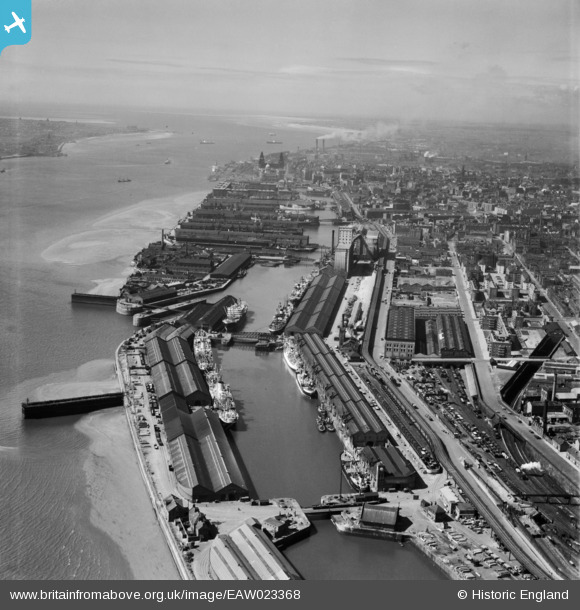
EAW023368 ENGLAND (1949). Toxteth Dock and Brunswick Dock, Liverpool, from the south-east, 1949
© Copyright OpenStreetMap contributors and licensed by the OpenStreetMap Foundation. 2026. Cartography is licensed as CC BY-SA.
Details
| Title | [EAW023368] Toxteth Dock and Brunswick Dock, Liverpool, from the south-east, 1949 |
| Reference | EAW023368 |
| Date | 24-May-1949 |
| Link | |
| Place name | LIVERPOOL |
| Parish | |
| District | |
| Country | ENGLAND |
| Easting / Northing | 334914, 387941 |
| Longitude / Latitude | -2.9786480375997, 53.384036043561 |
| National Grid Reference | SJ349879 |
Pins

Ginger79 |
Saturday 12th of April 2025 01:45:00 AM | |

austin |
Tuesday 12th of May 2020 07:18:56 PM | |
|
austin |
Tuesday 12th of May 2020 07:12:11 PM | |
|
austin |
Tuesday 12th of May 2020 07:09:42 PM | |
|
austin |
Tuesday 12th of May 2020 07:09:41 PM | |
|
austin |
Tuesday 12th of May 2020 07:09:41 PM | |
|
austin |
Tuesday 12th of May 2020 07:00:34 PM | |
|
austin |
Tuesday 12th of May 2020 06:58:27 PM | |
|
austin |
Tuesday 12th of May 2020 06:40:12 PM | |
|
austin |
Tuesday 12th of May 2020 06:40:11 PM | |
|
austin |
Tuesday 12th of May 2020 06:37:57 PM | |
|
Peter |
Tuesday 24th of December 2013 12:02:11 PM |
User Comment Contributions
Does anybody know what the jetty or abutment out to the Mersey from Brunswick dock in the above photo |
Riverside |
Tuesday 22nd of November 2016 01:00:46 PM |