
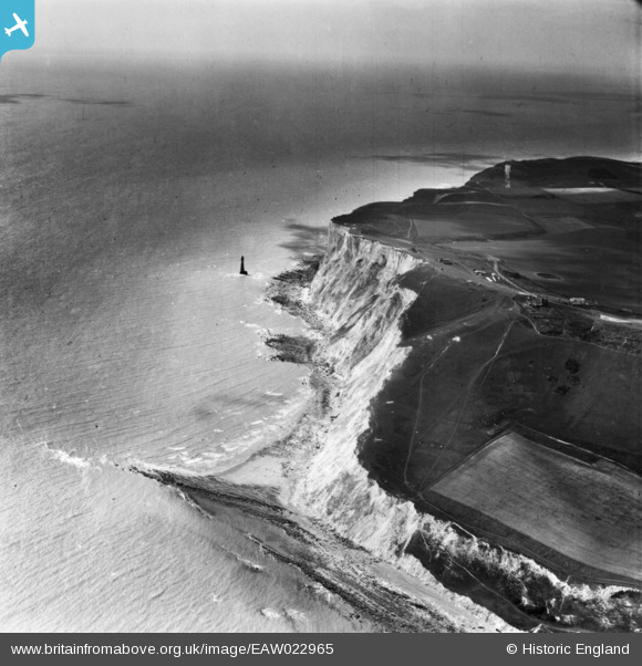
EAW022965 ENGLAND (1949). Beachy Head Lighthouse and the cliffs, Beachy Head, from the north-east, 1949. This image has been produced from a print.
© Copyright OpenStreetMap contributors and licensed by the OpenStreetMap Foundation. 2025. Cartography is licensed as CC BY-SA.
Details
| Title | [EAW022965] Beachy Head Lighthouse and the cliffs, Beachy Head, from the north-east, 1949. This image has been produced from a print. |
| Reference | EAW022965 |
| Date | 6-May-1949 |
| Link | |
| Place name | BEACHY HEAD |
| Parish | |
| District | |
| Country | ENGLAND |
| Easting / Northing | 559406, 95569 |
| Longitude / Latitude | 0.25932260574882, 50.73725541363 |
| National Grid Reference | TV594956 |
Pins

redmist |
Wednesday 4th of January 2023 08:09:37 PM | |
|
Mikeo1938 |
Monday 6th of October 2014 03:57:05 PM | |
|
Mikeo1938 |
Monday 6th of October 2014 03:49:15 PM | |
|
Mikeo1938 |
Monday 6th of October 2014 03:46:28 PM |
User Comment Contributions
Beachy Head |

Alan McFaden |
Friday 10th of October 2014 10:24:57 AM |
Beachy Head |
Alan McFaden |
Friday 10th of October 2014 10:24:38 AM |
Beachy Head Lighthouse |
Alan McFaden |
Friday 10th of October 2014 10:24:10 AM |