
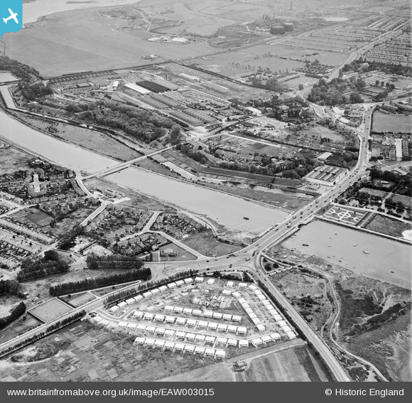
EAW003015 ENGLAND (1946). Ports Bridge, Ports Creek and prefabricated housing on Cosham Recreation Ground, Hilsea, 1946
© Copyright OpenStreetMap contributors and licensed by the OpenStreetMap Foundation. 2026. Cartography is licensed as CC BY-SA.
Details
| Title | [EAW003015] Ports Bridge, Ports Creek and prefabricated housing on Cosham Recreation Ground, Hilsea, 1946 |
| Reference | EAW003015 |
| Date | 3-October-1946 |
| Link | |
| Place name | HILSEA |
| Parish | |
| District | |
| Country | ENGLAND |
| Easting / Northing | 465666, 104515 |
| Longitude / Latitude | -1.0673700076677, 50.835875499307 |
| National Grid Reference | SU657045 |
Pins

Rich |
Wednesday 12th of March 2025 03:16:39 PM | |
|
Stephen Mirrington |
Sunday 19th of February 2023 03:21:10 PM | |
|
Stephen Mirrington |
Sunday 19th of February 2023 03:15:28 PM | |
|
ianhenden |
Monday 12th of September 2022 04:55:21 PM | |
|
Jeff@Clanfield |
Monday 8th of April 2019 07:15:12 PM | |
|
John Wass |
Tuesday 19th of January 2016 02:04:07 PM | |
|
David Emery |
Tuesday 17th of March 2015 09:13:47 PM | |

clippedwings |
Monday 9th of February 2015 09:41:35 PM | |
|
hoppy |
Thursday 20th of November 2014 03:06:40 AM | |
|
5tumb1ebum |
Friday 25th of July 2014 10:49:25 PM | |

greenchief |
Wednesday 7th of May 2014 10:09:56 AM | |
|
greenchief |
Wednesday 18th of December 2013 12:37:49 PM | |
|
greenchief |
Tuesday 27th of August 2013 02:54:23 PM | |
|
greenchief |
Tuesday 27th of August 2013 02:53:24 PM | |
A dislexic input should be Hilsea not Huksae |
greenchief |
Wednesday 18th of December 2013 12:39:36 PM |
User Comment Contributions

A distant aerial view looking west, 18.07.2014 courtesy Con Shields. |

Class31 |
Tuesday 22nd of July 2014 07:47:31 AM |
Note the steam train top left hand corner heading into Portsmouth. Open space behind is Portsmouth Airport. Prefabs in the foreground survived until early 1960's; 700 built across the city. |
Jim Graham |
Monday 4th of November 2013 07:36:24 PM |