
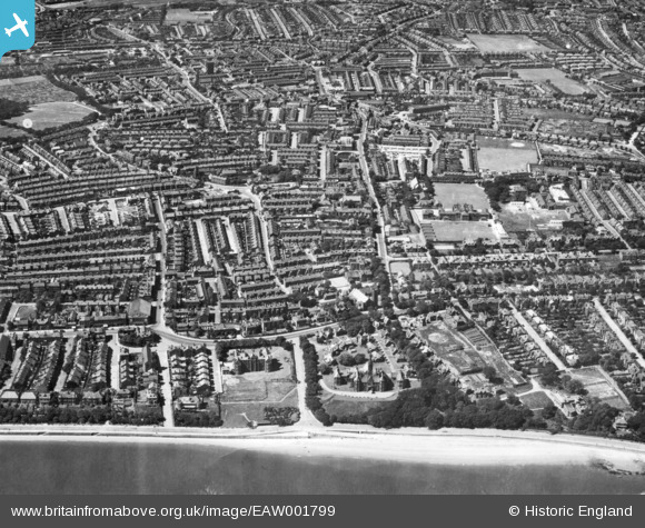
EAW001799 ENGLAND (1946). Manor Road and environs, Egremont, 1946. This image has been produced from a print.
© Copyright OpenStreetMap contributors and licensed by the OpenStreetMap Foundation. 2026. Cartography is licensed as CC BY-SA.
Details
| Title | [EAW001799] Manor Road and environs, Egremont, 1946. This image has been produced from a print. |
| Reference | EAW001799 |
| Date | 11-July-1946 |
| Link | |
| Place name | EGREMONT |
| Parish | |
| District | |
| Country | ENGLAND |
| Easting / Northing | 331361, 392272 |
| Longitude / Latitude | -3.0330050572478, 53.422513889047 |
| National Grid Reference | SJ314923 |
Pins

Saul Marks |
Tuesday 26th of May 2026 01:00:37 AM | |
|
Saul Marks |
Tuesday 26th of May 2026 12:59:35 AM | |
|
Saul Marks |
Tuesday 26th of May 2026 12:58:54 AM | |
|
Saul Marks |
Tuesday 26th of May 2026 12:57:27 AM | |
|
Saul Marks |
Tuesday 26th of May 2026 12:54:56 AM | |
|
Saul Marks |
Tuesday 26th of May 2026 12:54:09 AM | |
|
Rachel |
Wednesday 7th of February 2024 12:05:48 AM | |
|
andycarole |
Saturday 1st of July 2023 12:37:13 PM | |
|
Norton |
Friday 21st of February 2020 06:36:21 PM | |
|
Jess |
Wednesday 27th of December 2017 02:30:39 PM | |
|
daveybm |
Sunday 26th of July 2015 12:01:27 PM | |
|
daveybm |
Sunday 26th of July 2015 12:00:14 PM |