
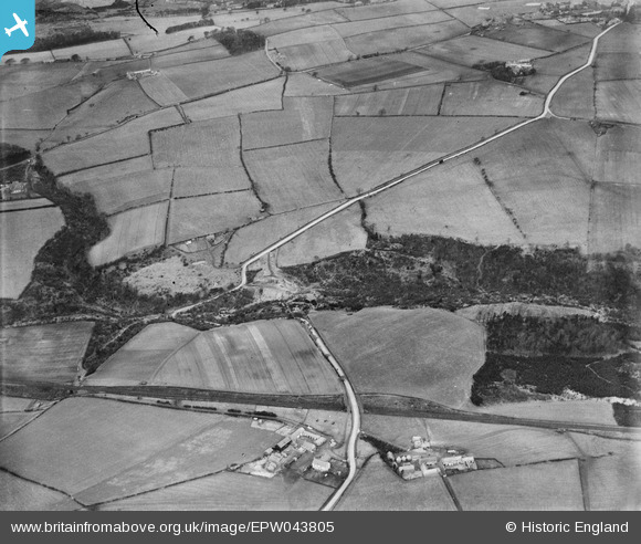
EPW043805 ENGLAND (1934). Thornley Lane and the Garesfield and Chopwell Railway, Winlaton, 1934
© Hawlfraint cyfranwyr OpenStreetMap a thrwyddedwyd gan yr OpenStreetMap Foundation. 2024. Trwyddedir y gartograffeg fel CC BY-SA.
Manylion
| Pennawd | [EPW043805] Thornley Lane and the Garesfield and Chopwell Railway, Winlaton, 1934 |
| Cyfeirnod | EPW043805 |
| Dyddiad | February-1934 |
| Dolen | |
| Enw lle | WINLATON |
| Plwyf | |
| Ardal | |
| Gwlad | ENGLAND |
| Dwyreiniad / Gogleddiad | 417219, 560841 |
| Hydred / Lledred | -1.7311830054006, 54.941855295996 |
| Cyfeirnod Grid Cenedlaethol | NZ172608 |
Pinnau
 Tired Hiker |
Monday 18th of September 2023 03:50:21 PM | |
J May |
Thursday 4th of March 2021 02:23:53 PM | |
totoro |
Tuesday 8th of March 2016 09:55:01 PM | |
totoro |
Tuesday 8th of March 2016 09:54:13 PM | |
totoro |
Tuesday 8th of March 2016 09:53:55 PM | |
totoro |
Tuesday 8th of March 2016 09:53:03 PM | |
totoro |
Tuesday 8th of March 2016 09:52:42 PM | |
totoro |
Tuesday 8th of March 2016 09:51:41 PM | |
totoro |
Tuesday 8th of March 2016 09:51:15 PM | |
totoro |
Tuesday 8th of March 2016 09:49:44 PM | |
totoro |
Tuesday 8th of March 2016 09:49:07 PM |
Cyfraniadau Grŵp
Garesfield and Chopwell Railway 1896 – 1961 Now "Old Colliery Railway Footpath". A short stretch of track on the footpath holds a couple of coal wagons. Initial use was t carry bricks to build the colliery, from High Spen to Chopwell. Subsequently used to move coal - 3000 tons per day. The line joined the "mainline" at High Spen where there had been a colliery since around 1800. The coal was taken to the River Tyne (Derwenthaugh). The mines at Chopwell and High Spen closed in 1960 and the line after passing from LNER to BR was closed. |
totoro |
Tuesday 8th of March 2016 09:46:30 PM |


