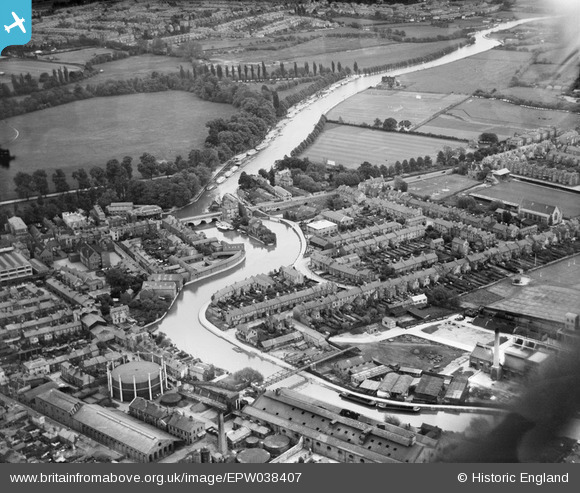
epw038407 ENGLAND (1932). Folly Bridge and environs, Oxford, 1932
© Copyright OpenStreetMap contributors and licensed by the OpenStreetMap Foundation. 2024. Cartography is licensed as CC BY-SA.
Nearby Images (9)
Details
| Title | [EPW038407] Folly Bridge and environs, Oxford, 1932 |
| Reference | EPW038407 |
| Date | June-1932 |
| Link | |
| Place name | OXFORD |
| Parish | |
| District | |
| Country | ENGLAND |
| Easting / Northing | 451367, 205504 |
| Longitude / Latitude | -1.255897985635, 51.745423332776 |
| National Grid Reference | SP514055 |
Pins
 Mike Floate |
Friday 12th of February 2016 08:46:34 PM | |
 Class31 |
Wednesday 14th of October 2015 10:07:31 AM | |
 Class31 |
Wednesday 14th of October 2015 10:06:37 AM | |
 ndaisley |
Monday 9th of September 2013 12:41:39 AM | |
 Memory Lane |
Thursday 7th of March 2013 03:29:20 PM |


![[EPW038407] Folly Bridge and environs, Oxford, 1932](http://britainfromabove.org.uk/sites/all/libraries/aerofilms-images/public/100x100/EPW/038/EPW038407.jpg)
![[EAW047926] Folly Bridge and environs in the snow, Grandpont, 1952](http://britainfromabove.org.uk/sites/all/libraries/aerofilms-images/public/100x100/EAW/047/EAW047926.jpg)
![[EPW038405] Folly Bridge and environs, Oxford, 1932](http://britainfromabove.org.uk/sites/all/libraries/aerofilms-images/public/100x100/EPW/038/EPW038405.jpg)
![[EAW014894] The city, Oxford, from the south, 1948. This image has been produced from a print.](http://britainfromabove.org.uk/sites/all/libraries/aerofilms-images/public/100x100/EAW/014/EAW014894.jpg)
![[EPW000821] View over Oxford and Christ Church Meadows, Oxford, from the west, 1920](http://britainfromabove.org.uk/sites/all/libraries/aerofilms-images/public/100x100/EPW/000/EPW000821.jpg)
![[EPW038406] St Aldate's Street and the city, Oxford, from the south-west, 1932](http://britainfromabove.org.uk/sites/all/libraries/aerofilms-images/public/100x100/EPW/038/EPW038406.jpg)
![[EPW000824] General view of Oxford following St Aldate's, Oxford, from the south-east, 1920](http://britainfromabove.org.uk/sites/all/libraries/aerofilms-images/public/100x100/EPW/000/EPW000824.jpg)
![[EPW000836] Grandpont, Oxford, from the south-east, 1920](http://britainfromabove.org.uk/sites/all/libraries/aerofilms-images/public/100x100/EPW/000/EPW000836.jpg)
![[EAW014895] The city, Oxford, from the south, 1948. This image has been produced from a damaged negative.](http://britainfromabove.org.uk/sites/all/libraries/aerofilms-images/public/100x100/EAW/014/EAW014895.jpg)