
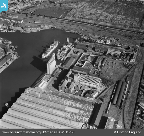
eaw011753 ENGLAND (1947). McDougalls Limited Wheatsheaf Flour Mills, Millwall, 1947
© Copyright OpenStreetMap contributors and licensed by the OpenStreetMap Foundation. 2024. Cartography is licensed as CC BY-SA.
Nearby Images (19)
EAW011753

EPW060548

EAW011752

EAW011755

EPW046148

EAW011757

EPW046147

EPW046146

EAW011756

EAW011759

EAW011758

EPW046145

EPW046149

EAW011754

EPW044131

EPW044130

EPW060455

EAW021114

EPW044136

Details
| Title | [EAW011753] McDougalls Limited Wheatsheaf Flour Mills, Millwall, 1947 |
| Reference | EAW011753 |
| Date | 9-October-1947 |
| Link | |
| Place name | MILLWALL |
| Parish | |
| District | |
| Country | ENGLAND |
| Easting / Northing | 537625, 178945 |
| Longitude / Latitude | -0.017354611784377, 51.492193038157 |
| National Grid Reference | TQ376789 |
Pins
 FREDSDAD |
Thursday 5th of May 2022 09:36:10 PM | |
Sparky |
Sunday 10th of September 2017 11:30:25 PM | |
MB |
Saturday 17th of September 2016 04:19:45 PM | |
MB |
Saturday 17th of September 2016 04:16:52 PM | |
MB |
Saturday 17th of September 2016 04:16:15 PM | |
MB |
Saturday 17th of September 2016 04:15:49 PM | |
SimonT |
Thursday 28th of June 2012 09:35:39 PM |
User Comment Contributions
McDougalls were a Manchester milling family. Three brothers moved down to Millwall Dock circa 1870 [G Jones, The Millers, 2001, 214] |
MB |
Saturday 17th of September 2016 04:18:36 PM |


