
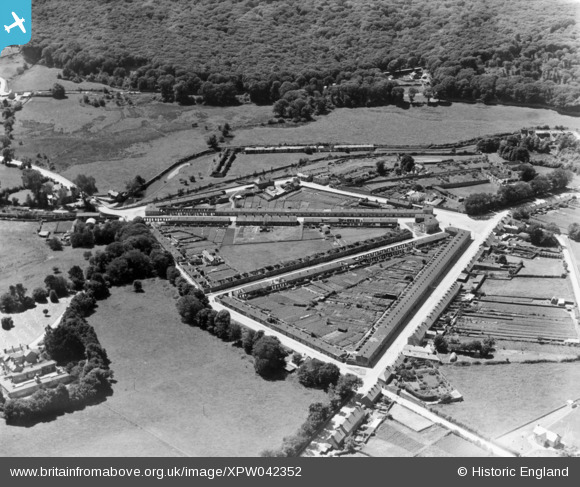
XPW042352 IRELAND (1933). General View, Portlaw , Waterford, Ireland, 1933. Oblique aerial photograph taken facing South/West.
© Copyright OpenStreetMap contributors and licensed by the OpenStreetMap Foundation. 2024. Cartography is licensed as CC BY-SA.
Details
| Title | [XPW042352] General View, Portlaw , Waterford, Ireland, 1933. Oblique aerial photograph taken facing South/West. |
| Reference | XPW042352 |
| Date | 1933 |
| Link | |
| Place name | PORTLAW |
| Parish | IRELAND |
| District | |
| Country | IRELAND |
| Easting / Northing | 37429, 278725 |
| Longitude / Latitude | -7.318603, 52.28667 |
| National Grid Reference |
Pins
 John Swain |
Saturday 11th of October 2014 09:29:04 AM | |
John Swain |
Saturday 11th of October 2014 09:09:37 AM | |
John Swain |
Saturday 11th of October 2014 09:07:15 AM | |
John Swain |
Saturday 11th of October 2014 09:05:50 AM | |
John Swain |
Saturday 11th of October 2014 09:05:10 AM | |
John Swain |
Saturday 11th of October 2014 09:04:24 AM | |
John Swain |
Saturday 11th of October 2014 09:03:54 AM | |
John Swain |
Saturday 11th of October 2014 09:03:13 AM | |
John Swain |
Saturday 11th of October 2014 09:02:27 AM | |
John Swain |
Saturday 11th of October 2014 09:01:39 AM | |
John Swain |
Saturday 11th of October 2014 09:00:27 AM | |
John Swain |
Saturday 11th of October 2014 08:59:45 AM | |
John Swain |
Saturday 11th of October 2014 08:59:15 AM | |
John Swain |
Saturday 11th of October 2014 08:58:46 AM | |
John Swain |
Saturday 11th of October 2014 08:58:12 AM |
User Comment Contributions
The population of Portlaw was about 950 when this photo was taken (947 in 1936 Census) and is currently just over 1,000. The distinctive 19th century layout is still instantly recognisable on present-day maps. Ref: most of the notes and labels have been obtained from An Introduction to the Architectural Heritage of County Waterford, Government of Ireland, 2004. |
John Swain |
Saturday 11th of October 2014 09:37:40 AM |
In the 1820s a "Model" village was developed at Portlaw to house workers for the successful local cotton industry, which had been set up by the Quaker Malcomson family on the banks of the Clodiagh River, where the road between Carrick-on-Suir and Waterford crosses the small tributary of the Suir. In the mid-19th century, Joseph Malcomson redesigned the settlement entailing the use of wide, radial roads with uniform house frontages and straight axes meeting at the western end of the village in The Square. Workers' accommodation comprised 50 2-storey and more than 250 single-storey houses of a similar pattern and interior design. The commercial core of the village once contained a hotel and the cotton factories were located beyond the village, on the banks of the Clodiagh, just off to the right of the picture. The mill closed down in 1904, but it was replaced in the mid-20th century by a tannery. The attractive location of Portlaw is enhanced by the proximity to the beautiful demesne of Curraghmore on its western side and the former Malcomson estates to the north. |
John Swain |
Saturday 11th of October 2014 09:28:06 AM |


