
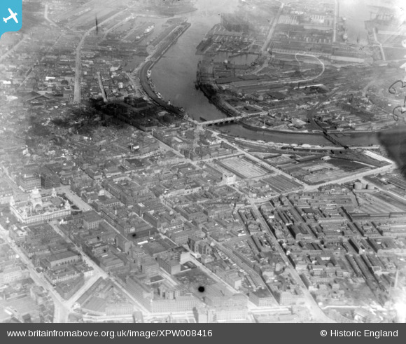
XPW008416 NORTHERN IRELAND (1923). City Hall, Queens Bridge and Harland & Wolff, Belfast, Belfast, Northern Ireland, 1923. Oblique aerial photograph taken facing North/East.
© Copyright OpenStreetMap contributors and licensed by the OpenStreetMap Foundation. 2024. Cartography is licensed as CC BY-SA.
Nearby Images (6)
XPW008416

XPW008418

XAW009546

XPW015520

XAW033114

XAW033113

Details
| Title | [XPW008416] City Hall, Queens Bridge and Harland & Wolff, Belfast, Belfast, Northern Ireland, 1923. Oblique aerial photograph taken facing North/East. |
| Reference | XPW008416 |
| Date | 1923 |
| Link | |
| Place name | BELFAST |
| Parish | NORTHERN IRELAND |
| District | |
| Country | NORTHERN IRELAND |
| Easting / Northing | 146421, 529220 |
| Longitude / Latitude | -5.927016, 54.594356 |
| National Grid Reference |
Pins
 SebastianG1 |
Thursday 8th of June 2023 11:50:01 AM | |
Blackjack |
Saturday 1st of November 2014 02:18:44 PM | |
billh35 |
Monday 13th of October 2014 04:25:25 PM | |
billh35 |
Monday 13th of October 2014 04:24:52 PM | |
billh35 |
Monday 13th of October 2014 04:24:31 PM | |
billh35 |
Monday 13th of October 2014 04:24:11 PM |


