
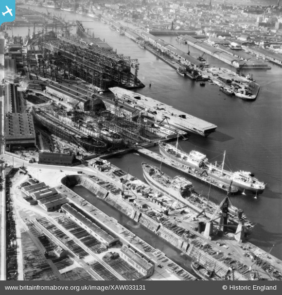
XAW033131 NORTHERN IRELAND (1950). General View, Belfast, Belfast, Northern Ireland, 1950. Oblique aerial photograph taken facing South/West.
© Copyright OpenStreetMap contributors and licensed by the OpenStreetMap Foundation. 2024. Cartography is licensed as CC BY-SA.
Nearby Images (10)
XAW033131

EAW018042

XAW033133

EAW018046

XPW043374

XAW033130

XPW042458

XAW009555

XPW043373

EAW511323

Details
| Title | [XAW033131] General View, Belfast, Belfast, Northern Ireland, 1950. Oblique aerial photograph taken facing South/West. |
| Reference | XAW033131 |
| Date | 15-September-1950 |
| Link | |
| Place name | BELFAST |
| Parish | NORTHERN IRELAND |
| District | |
| Country | NORTHERN IRELAND |
| Easting / Northing | 147886, 531128 |
| Longitude / Latitude | -5.906044, 54.612195 |
| National Grid Reference |
Pins
 Mike |
Tuesday 7th of October 2014 12:04:52 AM | |
I don't think it is HMS Ark Royal but a later photo shows there are three more carriers around this one. I have a feeling they being built for foreign navies. |
John Wass |
Tuesday 18th of November 2014 03:14:25 PM |
The Ark Royal of the day was built by Cammell Laird at Birkenhead. HMS Eagle, finally completed late 1951, is one candidate.The light carriers HMS Centaur & HMS Hermes were completed in 1953/4. |
gBr |
Sunday 11th of January 2015 06:21:46 AM |


