
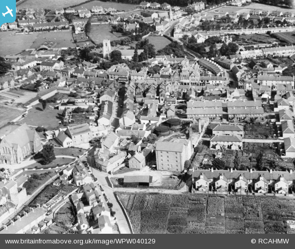
WPW040129 WALES (1932). General view of Abergele, oblique aerial view. 5"x4" black and white glass plate negative.
© Copyright OpenStreetMap contributors and licensed by the OpenStreetMap Foundation. 2024. Cartography is licensed as CC BY-SA.
Nearby Images (11)
WAW031601

WAW031602

WAW031603

WPW024959

WPW025174

WPW025175

WPW025176

WPW025177

WPW040129

WPW040131

WPW040132

Details
| Title | [WPW040129] General view of Abergele, oblique aerial view. 5"x4" black and white glass plate negative. |
| Reference | WPW040129 |
| Date | 1932 |
| Link | Coflein Archive Item 6369701 |
| Place name | |
| Parish | |
| District | |
| Country | WALES |
| Easting / Northing | 294640, 377560 |
| Longitude / Latitude | -3.5805590894726, 53.284251363501 |
| National Grid Reference | SH946776 |
Pins
 Electric gypsy |
Saturday 22nd of September 2012 08:29:03 PM | |
Robbieca |
Monday 10th of September 2012 07:19:08 PM | |
Robbieca |
Monday 10th of September 2012 07:11:29 PM | |
Robbieca |
Monday 10th of September 2012 07:09:28 PM | |
Robbieca |
Monday 10th of September 2012 07:08:48 PM | |
Robbieca |
Monday 10th of September 2012 07:05:30 PM | |
Robbieca |
Monday 10th of September 2012 07:04:23 PM | |
Robbieca |
Monday 10th of September 2012 07:02:51 PM | |
Robbieca |
Monday 10th of September 2012 06:59:41 PM | |
Robbieca |
Monday 10th of September 2012 06:51:29 PM | |
Robbieca |
Monday 10th of September 2012 06:50:19 PM | |
Robbieca |
Monday 10th of September 2012 05:56:31 PM | |
Robbieca |
Monday 10th of September 2012 05:55:09 PM | |
Robbieca |
Monday 10th of September 2012 05:53:49 PM | |
Robbieca |
Monday 10th of September 2012 05:52:19 PM | |
Robbieca |
Monday 10th of September 2012 05:51:16 PM | |
Robbieca |
Monday 10th of September 2012 05:49:36 PM | |
 Class31 |
Wednesday 4th of July 2012 10:46:20 AM | |
Class31 |
Wednesday 4th of July 2012 10:42:25 AM | |
Class31 |
Wednesday 4th of July 2012 10:41:11 AM | |
Class31 |
Wednesday 4th of July 2012 10:40:52 AM | |
Class31 |
Wednesday 4th of July 2012 10:38:43 AM | |
Class31 |
Wednesday 4th of July 2012 10:36:50 AM | |
Class31 |
Wednesday 4th of July 2012 10:36:22 AM | |
This is Llanfair Road, Chapel Street ends at junction of High Street. |
Robbieca |
Monday 10th of September 2012 06:26:50 PM |
Class31 |
Wednesday 4th of July 2012 10:35:16 AM |
User Comment Contributions
Its remarkable how many alloments people had in Abergele during the 30,s |
Roger |
Tuesday 10th of November 2015 07:40:03 PM |
The centre of Abergele looking North. Parish Church of st. Michael is prominent. It is interesting that the commercial centre appears to have moved away from the High Street. |
Class31 |
Monday 10th of September 2012 06:47:42 PM |
The commercial centre of Abergele has always been Market street, High Street only came into being in the 1920's when new houses were built behind Bryntirion Terrace which is on Llanfair Road. |
Robbieca |
Monday 10th of September 2012 06:47:42 PM |


