
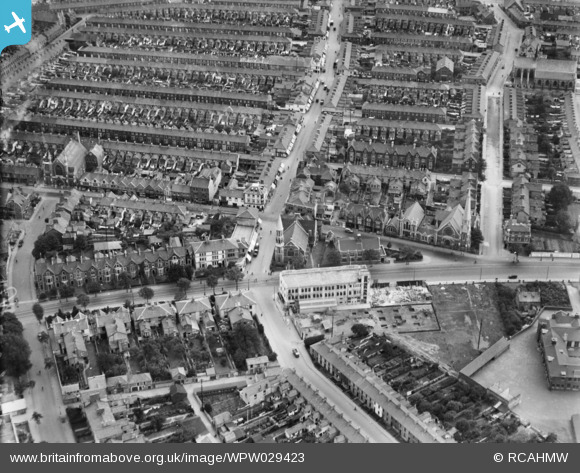
WPW029423 WALES (1929). View of residential area Cardiff, oblique aerial view. 5"x4" black and white glass plate negative.
© Copyright OpenStreetMap contributors and licensed by the OpenStreetMap Foundation. 2024. Cartography is licensed as CC BY-SA.
Nearby Images (48)
WPW001000

WPW001001

WPW001002

WPW001003

WPW001004

WPW001008

WPW001009

WPW001010

WPW001014

WPW001035

WPW016914

WPW016915

WPW016916

WPW016917

WPW016918

WPW016919

WPW016920

WPW029422

WPW029423

WPW029424

WPW029425

WPW029427

WPW029429

WPW041787

WPW041788

WPW041789

WPW041790

WPW041791

WPW041792

WPW041793

WPW041794

WPW041795

WPW052624

WPW052659

WPW052660

WPW052661

WPW052662

WPW052663

WPW052664

WPW054861

WPW054863

WPW054864

WPW054865

WPW055450

WPW055451

WPW055452

WPW055453

WPW055454

Details
| Title | [WPW029423] View of residential area Cardiff, oblique aerial view. 5"x4" black and white glass plate negative. |
| Reference | WPW029423 |
| Date | 1929 |
| Link | Coflein Archive Item 6378029 |
| Place name | |
| Parish | |
| District | |
| Country | WALES |
| Easting / Northing | 318170, 176360 |
| Longitude / Latitude | -3.1785006478589, 51.479784917149 |
| National Grid Reference | ST182764 |
Pins
 Class31 |
Tuesday 29th of July 2014 08:46:13 AM | |
Class31 |
Tuesday 29th of July 2014 08:37:30 AM | |
Class31 |
Tuesday 29th of July 2014 08:36:24 AM | |
Class31 |
Tuesday 29th of July 2014 08:35:31 AM | |
 huwbbc |
Thursday 28th of June 2012 10:39:41 PM | |
huwbbc |
Thursday 28th of June 2012 10:30:56 PM | |
Cardiffman |
Wednesday 27th of June 2012 07:50:46 PM | |
Cardiffman |
Wednesday 27th of June 2012 07:49:32 PM | |
dgeats |
Wednesday 27th of June 2012 01:37:25 PM | |
dgeats |
Wednesday 27th of June 2012 01:37:23 PM | |
dgeats |
Wednesday 27th of June 2012 01:36:04 PM | |
dgeats |
Wednesday 27th of June 2012 01:34:17 PM | |
peterg |
Wednesday 27th of June 2012 07:26:14 AM | |
peterg |
Wednesday 27th of June 2012 07:25:48 AM | |
peterg |
Wednesday 27th of June 2012 07:23:28 AM |
User Comment Contributions
The white building was known as 'Graham Buildings' which housed the Ministry of Transport and other government organisations together with Merretts Ltd, a popular local bakers and confectioners. At the far lower right is the edge of the old Cardiff High School for Boys ( where I attended in the fifties). Both buildings have since been demolished. ' |
Cardiffman |
Friday 29th of June 2012 06:09:19 PM |
Graham Bulding was also the place where we use to go for our Diving Tests. It was certainly the place when I took my test in 1963. |
Siggy708 |
Friday 29th of June 2012 06:09:19 PM |
This appers to be Newport Road close to Splott. i can recognise part of my old school, Cardiff high for Boys. |
Norman Hoadly |
Tuesday 26th of June 2012 07:53:24 PM |