
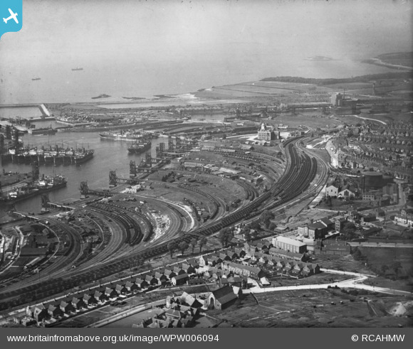
WPW006094 WALES (1921). General view of Barry showing docks, oblique aerial view. 5"x4" black and white glass plate negative.
© Copyright OpenStreetMap contributors and licensed by the OpenStreetMap Foundation. 2024. Cartography is licensed as CC BY-SA.
Nearby Images (15)
WPW006090

WPW006093

WPW006094

WPW006096

WPW008635

WPW024955A

WPW029392

WPW029399

WPW029400

WPW029456

WPW029458

WPW029459

WPW029461

WPW029462

WPW041252

Details
| Title | [WPW006094] General view of Barry showing docks, oblique aerial view. 5"x4" black and white glass plate negative. |
| Reference | WPW006094 |
| Date | 1921 |
| Link | Coflein Archive Item 6370319 |
| Place name | |
| Parish | |
| District | |
| Country | WALES |
| Easting / Northing | 311000, 166000 |
| Longitude / Latitude | -3.2791309458519, 51.385561791936 |
| National Grid Reference | ST110660 |
Pins
 Ben Salter |
Sunday 31st of March 2024 05:01:20 PM | |
trelissick |
Wednesday 5th of June 2013 09:48:20 PM | |
MB |
Sunday 14th of October 2012 10:11:22 AM | |
MB |
Sunday 14th of October 2012 10:10:47 AM |
User Comment Contributions
definatly reversed. trelissick |
trelissick |
Wednesday 13th of March 2013 10:32:58 PM |
 This is the correct viewpoint with the docks on the RIGHT hand side of the dock offices and Sully island in the background. |
Gina |
Monday 15th of October 2012 10:36:15 AM |
This photograph has been printed back to front! |
Gina |
Monday 8th of October 2012 08:49:53 PM |


