
SPW062639 SCOTLAND (1939). Loch Lomond, general view, showing Inchfad and Inchlonaig. An oblique aerial photograph taken facing north.

© Copyright OpenStreetMap contributors and licensed by the OpenStreetMap Foundation. 2024. Cartography is licensed as CC BY-SA.
Details
| Title | [SPW062639] Loch Lomond, general view, showing Inchfad and Inchlonaig. An oblique aerial photograph taken facing north. |
| Reference | SPW062639 |
| Date | 1939 |
| Link | Canmore Collection item 1259560 |
| Place name | |
| Parish | BUCHANAN |
| District | STIRLING |
| Country | SCOTLAND |
| Easting / Northing | 238805, 691817 |
| Longitude / Latitude | -4.591326365588, 56.091968598407 |
| National Grid Reference | NS388918 |
Pins
Be the first to add a comment to this image!
User Comment Contributions
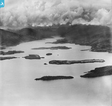 Here we can see three of the main elements in the weather systems that shape our planet - water, mountains and clouds. Clouds are moisture-bearing weather formations that form when moisture-laden air rises and condenses in the atmosphere. Mountains encourage air to flow upwards and condense, eventually causing the water content in the cloud to be discharged in the form of rain (or hail or snow, if the air temperature is cold enough). Rain flows off the land into stream and rivers, and is eventually collected in the sea, or in large lakes or lochs, as we see here. |
 AlMu |
Thursday 8th of May 2014 05:38:57 PM |
The loch islands of Inchmurrin, Creinch, Torrinch, and Inchcailloch all form part of the Highland Boundary Fault. |
Brian Wilkinson |
Friday 25th of May 2012 03:02:50 PM |


