
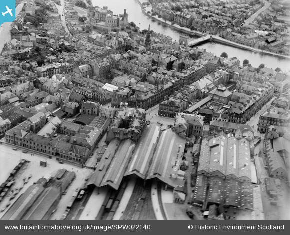
SPW022140 SCOTLAND (1928). Inverness, general view, showing Inverness Station and Ness Bridge. An oblique aerial photograph taken facing south-west.
© Copyright OpenStreetMap contributors and licensed by the OpenStreetMap Foundation. 2024. Cartography is licensed as CC BY-SA.
Nearby Images (17)
SPW022140

SAR016705

SPW022147

SAW022606

SAW022607

SPW040496

SAW022604

SAW022603

SAW022609

SAW022610

SAW022605

SAW022608

SAW022602

SPW040499

SPW022139

SPW033826

SPW022149

Details
| Title | [SPW022140] Inverness, general view, showing Inverness Station and Ness Bridge. An oblique aerial photograph taken facing south-west. |
| Reference | SPW022140 |
| Date | 1928 |
| Link | Canmore Collection item 1256509 |
| Place name | |
| Parish | INVERNESS AND BONA |
| District | INVERNESS |
| Country | SCOTLAND |
| Easting / Northing | 266715, 845389 |
| Longitude / Latitude | -4.2231758798266, 57.479347426 |
| National Grid Reference | NH667454 |
Pins
 Robbieca |
Thursday 4th of June 2015 07:03:03 PM | |
Robbieca |
Thursday 4th of June 2015 06:58:19 PM | |
Robbieca |
Thursday 4th of June 2015 06:56:31 PM | |
Robbieca |
Thursday 4th of June 2015 06:49:29 PM | |
Robbieca |
Thursday 4th of June 2015 06:48:17 PM | |
Robbieca |
Thursday 4th of June 2015 06:46:34 PM | |
Robbieca |
Thursday 4th of June 2015 06:45:57 PM |
User Comment Contributions
Inverness Castle now the Law Courts |
Robbieca |
Thursday 4th of June 2015 06:50:55 PM |


