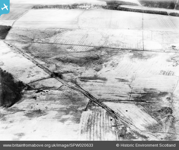
SPW020633 SCOTLAND (1928) [Unlocated]. Unlocated moorland. An oblique aerial photograph.
© Copyright OpenStreetMap contributors and licensed by the OpenStreetMap Foundation. 2024. Cartography is licensed as CC BY-SA.
Nearby Images (48)
Details
| Title | [SPW020633] Unlocated moorland. An oblique aerial photograph. |
| Reference | SPW020633 |
| Date | 1928 |
| Link | Canmore Collection item 1256391 |
| Place name | |
| Parish | |
| District | |
| Country | SCOTLAND |
| Easting / Northing | 0, 0 |
| Longitude / Latitude | -7.556448482059, 49.766185796754 |
| National Grid Reference | SV000000 |
Pins
 Rebecca |
Friday 1st of November 2013 03:30:29 PM | |
Maybe it shows different vegetation where land drain pipes are dug in underneath. Sometimes these wide bands are evidence of medieval field systems- strip lynchets. On moorland it's more likely that it's drainage and improvement? |
 Will Wallace |
Saturday 24th of May 2014 01:09:24 PM |
 Pete65 |
Saturday 4th of May 2013 06:27:14 PM | |
If it is a railway, it's not the CHPR. Their inclines were double track all the way down. There were other inclines, though, that used this short passing loop arrangement. |
 Maitland |
Monday 20th of January 2014 04:08:01 PM |
 ewnmcg |
Sunday 29th of July 2012 05:46:41 PM | |
Unlikely, as the geometry and scale of the feature does not fit that of such features on a railway. It looks much more like a farm track where a new route has been selected around a wet patch.... indeed farm tracks, with tractor/wagon ruts, do have some the of the characteristics of railway lines if not the conventional geometry. |
 Maurice |
Friday 4th of January 2013 02:07:04 PM |
 BigglesH |
Monday 16th of July 2012 03:14:20 AM |
User Comment Contributions
Looks to me like a minor road or farm track crossing largely level counryside - I don't see the evidence for it being a railway but happy to be corrected. |
 Calchfaen |
Saturday 31st of August 2013 04:13:11 PM |
Looks very like Elsdon Northumbria, but can't find an exact match |
 TomRobin |
Tuesday 20th of November 2012 11:28:17 PM |


![[EPW000143] UNLOCATED](http://britainfromabove.org.uk/sites/all/libraries/aerofilms-images/public/100x100/EPW/000/EPW000143.jpg)
![[EPW000667] Vessel at Sea](http://britainfromabove.org.uk/sites/all/libraries/aerofilms-images/public/100x100/EPW/000/EPW000667.jpg)
![[EPW005260] UNLOCATED](http://britainfromabove.org.uk/sites/all/libraries/aerofilms-images/public/100x100/EPW/005/EPW005260.jpg)
![[EPW006389] The R33 airship in flight over the Epsom Downs (unlocated), 1921](http://britainfromabove.org.uk/sites/all/libraries/aerofilms-images/public/100x100/EPW/006/EPW006389.jpg)
![[EPW007181] UNLOCATED](http://britainfromabove.org.uk/sites/all/libraries/aerofilms-images/public/100x100/EPW/007/EPW007181.jpg)
![[EPW015853] Cloudscape, 1926](http://britainfromabove.org.uk/sites/all/libraries/aerofilms-images/public/100x100/EPW/015/EPW015853.jpg)
![[EPW015854] Cloudscape, 1926](http://britainfromabove.org.uk/sites/all/libraries/aerofilms-images/public/100x100/EPW/015/EPW015854.jpg)
![[EPW015855] Cloudscape, 1926](http://britainfromabove.org.uk/sites/all/libraries/aerofilms-images/public/100x100/EPW/015/EPW015855.jpg)
![[EPW016012] UNLOCATED](http://britainfromabove.org.uk/sites/all/libraries/aerofilms-images/public/100x100/EPW/016/EPW016012.jpg)
![[EPW016510] Cloudscape, 1926](http://britainfromabove.org.uk/sites/all/libraries/aerofilms-images/public/100x100/EPW/016/EPW016510.jpg)
![[EPW016641] EPW016641](http://britainfromabove.org.uk/sites/all/libraries/aerofilms-images/public/100x100/EPW/016/EPW016641.jpg)
![[EPW017028] Cloudscape, 1926](http://britainfromabove.org.uk/sites/all/libraries/aerofilms-images/public/100x100/EPW/017/EPW017028.jpg)
![[EPW017029] Cloudscape, 1926](http://britainfromabove.org.uk/sites/all/libraries/aerofilms-images/public/100x100/EPW/017/EPW017029.jpg)
![[EPW017136] A vessel at sea off Beachy Head, from the east, 1926](http://britainfromabove.org.uk/sites/all/libraries/aerofilms-images/public/100x100/EPW/017/EPW017136.jpg)
![[SAW003585] Skiddaw, Lake District. Oblique aerial photograph.](http://britainfromabove.org.uk/sites/all/libraries/aerofilms-images/public/100x100/SAW/003/SAW003585.jpg)
![[SAW003586] Unlocated mountains, possibly near Ben Nevis. An oblique aerial photograph.](http://britainfromabove.org.uk/sites/all/libraries/aerofilms-images/public/100x100/SAW/003/SAW003586.jpg)
![[SAW009337] Wigtown Bay, general view, showing Ringdoo Point. An oblique aerial photograph taken facing west.](http://britainfromabove.org.uk/sites/all/libraries/aerofilms-images/public/100x100/SAW/009/SAW009337.jpg)
![[SAW009800] Clouds. An oblique aerial photograph.](http://britainfromabove.org.uk/sites/all/libraries/aerofilms-images/public/100x100/SAW/009/SAW009800.jpg)
![[SAW009801] Clouds. An oblique aerial photograph.](http://britainfromabove.org.uk/sites/all/libraries/aerofilms-images/public/100x100/SAW/009/SAW009801.jpg)
![[SAW009802] Unlocated, Scotland, 1947. An oblique Aerial photograph.](http://britainfromabove.org.uk/sites/all/libraries/aerofilms-images/public/100x100/SAW/009/SAW009802.jpg)
![[SAW010734] Clouds. An oblique aerial photograph.](http://britainfromabove.org.uk/sites/all/libraries/aerofilms-images/public/100x100/SAW/010/SAW010734.jpg)
![[SAW014737] Dalliefour Wood and River Dee, Balmoral Estate. An oblique aerial photograph taken facing east.](http://britainfromabove.org.uk/sites/all/libraries/aerofilms-images/public/100x100/SAW/014/SAW014737.jpg)
![[SAW017926] Unlocated image of haymaking, Dunbartonshire. An oblique aerial photograph.](http://britainfromabove.org.uk/sites/all/libraries/aerofilms-images/public/100x100/SAW/017/SAW017926.jpg)
![[SAW017927] Loch Ard Forest, general view showing Beinn Bhreac, Loch Ard and Ben Venue. An oblique aerial photograph taken facing north-east. This image has been produced from a damaged negative.](http://britainfromabove.org.uk/sites/all/libraries/aerofilms-images/public/100x100/SAW/017/SAW017927.jpg)
![[SAW032504] Unlocated country house, possibly near Ardanaiseig. Oblique aerial photograph. This image has been produced from a crop marked negative.](http://britainfromabove.org.uk/sites/all/libraries/aerofilms-images/public/100x100/SAW/032/SAW032504.jpg)
![[SPW020275] Scottish Dyes Ltd. Works, Grangemouth. An oblique aerial photograph taken facing north-west.](http://britainfromabove.org.uk/sites/all/libraries/aerofilms-images/public/100x100/SPW/020/SPW020275.jpg)
![[SPW020280] Birds flying low between Grangemouth and Culross, Firth of Forth. An oblique aerial photograph.](http://britainfromabove.org.uk/sites/all/libraries/aerofilms-images/public/100x100/SPW/020/SPW020280.jpg)
![[SPW020281] Birds flying low between Grangemouth and Culross, Firth of Forth. An oblique aerial photograph.](http://britainfromabove.org.uk/sites/all/libraries/aerofilms-images/public/100x100/SPW/020/SPW020281.jpg)
![[SPW020284] Ochil Hills, general view, showing Carsebreck Loch and Lower and Upper Rhynd Reservoirs. An oblique aerial photograph taken facing north-west.](http://britainfromabove.org.uk/sites/all/libraries/aerofilms-images/public/100x100/SPW/020/SPW020284.jpg)
![[SPW020632] Unlocated moorland. An oblique aerial photograph.](http://britainfromabove.org.uk/sites/all/libraries/aerofilms-images/public/100x100/SPW/020/SPW020632.jpg)
![[SPW020633] Unlocated moorland. An oblique aerial photograph.](http://britainfromabove.org.uk/sites/all/libraries/aerofilms-images/public/100x100/SPW/020/SPW020633.jpg)
![[SPW027083] Unlocated hills in Peeblesshire. An oblique aerial photograph.](http://britainfromabove.org.uk/sites/all/libraries/aerofilms-images/public/100x100/SPW/027/SPW027083.jpg)
![[SPW049776] Queen Mary, Firth of Clyde. An oblique aerial photograph.](http://britainfromabove.org.uk/sites/all/libraries/aerofilms-images/public/100x100/SPW/049/SPW049776.jpg)
![[SPW049777] Queen Mary, Firth of Clyde. An oblique aerial photograph.](http://britainfromabove.org.uk/sites/all/libraries/aerofilms-images/public/100x100/SPW/049/SPW049777.jpg)
![[SPW049779] Queen Mary, Firth of Clyde. An oblique aerial photograph.](http://britainfromabove.org.uk/sites/all/libraries/aerofilms-images/public/100x100/SPW/049/SPW049779.jpg)
![[SPW049783] Queen Mary, Firth of Clyde. An oblique aerial photograph.](http://britainfromabove.org.uk/sites/all/libraries/aerofilms-images/public/100x100/SPW/049/SPW049783.jpg)
![[SPW049791] Queen Mary, River Clyde. An oblique aerial photograph.](http://britainfromabove.org.uk/sites/all/libraries/aerofilms-images/public/100x100/SPW/049/SPW049791.jpg)
![[SPW049798] Queen Mary, Firth of Clyde. An oblique aerial photograph.](http://britainfromabove.org.uk/sites/all/libraries/aerofilms-images/public/100x100/SPW/049/SPW049798.jpg)
![[SPW049801] Queen Mary, Firth of Clyde. An oblique aerial photograph.](http://britainfromabove.org.uk/sites/all/libraries/aerofilms-images/public/100x100/SPW/049/SPW049801.jpg)
![[SPW049827] Queen Mary, Firth of Clyde. Speed trials. An oblique aerial photograph. This image has been produced from a damaged negative.](http://britainfromabove.org.uk/sites/all/libraries/aerofilms-images/public/100x100/SPW/049/SPW049827.jpg)
![[SPW049828] Queen Mary, Firth of Clyde. Speed trials. An oblique aerial photograph. This image has been produced from a damaged negative.](http://britainfromabove.org.uk/sites/all/libraries/aerofilms-images/public/100x100/SPW/049/SPW049828.jpg)
![[SPW049831] Queen Mary, Firth of Clyde. Speed trials. An oblique aerial photograph. This image has been produced from a damaged negative.](http://britainfromabove.org.uk/sites/all/libraries/aerofilms-images/public/100x100/SPW/049/SPW049831.jpg)
![[SPW049832] Queen Mary, Firth of Clyde. Speed trials. An oblique aerial photograph.](http://britainfromabove.org.uk/sites/all/libraries/aerofilms-images/public/100x100/SPW/049/SPW049832.jpg)
![[SPW049834] Queen Mary, Firth of Clyde. Speed trials. An oblique aerial photograph.](http://britainfromabove.org.uk/sites/all/libraries/aerofilms-images/public/100x100/SPW/049/SPW049834.jpg)
![[SPW049948] Queen Mary, Firth of Clyde. Speed trials. An oblique aerial photograph.](http://britainfromabove.org.uk/sites/all/libraries/aerofilms-images/public/100x100/SPW/049/SPW049948.jpg)
![[SPW049949] Queen Mary, Firth of Clyde. Speed trials. An oblique aerial photograph.](http://britainfromabove.org.uk/sites/all/libraries/aerofilms-images/public/100x100/SPW/049/SPW049949.jpg)
![[SPW051009] Unlocated area within the Glenapp Estate. An oblique aerial photograph.](http://britainfromabove.org.uk/sites/all/libraries/aerofilms-images/public/100x100/SPW/051/SPW051009.jpg)
![[SPW062638] Unlocated countryside. An oblique aerial photograph.](http://britainfromabove.org.uk/sites/all/libraries/aerofilms-images/public/100x100/SPW/062/SPW062638.jpg)


