
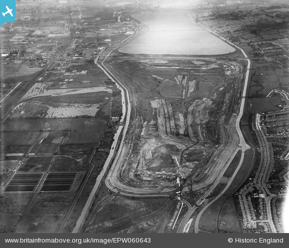
EPW060643 ENGLAND (1939). The William Girling Reservoir under construction, King George's Reservoir and environs, Enfield, 1939
© Copyright OpenStreetMap contributors and licensed by the OpenStreetMap Foundation. 2024. Cartography is licensed as CC BY-SA.
Nearby Images (35)
EPW060643

EAW044486

EPW058472
 Reservoir under construction, Edmonton, 1938")
EPW050865

EPW050857

EPW056322

EPW055969

EPW060640

EAW040924

EPW060641

EPW053844
 Reservoir under construction, Edmonton, 1937")
EPW060642

EPW055974

EPW060628

EPW053847
 Reservoir under construction, Edmonton, 1937")
EPW056318

EAW044489

EPW060633

EPW056812

EPW060636

EAW040969

EAW040927

EPW052279

EPW052286

EPW048912

EPW056828

EPW056824

EPW055984

EPW055977

EPW058458
 Reservoir under construction, Edmonton, 1938")
EPW049725

EPW050868

EPW053852
 Reservoir under construction, Edmonton, 1937")
EPW053848
 Reservoir under construction, Edmonton, 1937")
EPW049526

Details
| Title | [EPW060643] The William Girling Reservoir under construction, King George's Reservoir and environs, Enfield, 1939 |
| Reference | EPW060643 |
| Date | 2-March-1939 |
| Link | |
| Place name | ENFIELD |
| Parish | |
| District | |
| Country | ENGLAND |
| Easting / Northing | 536442, 193763 |
| Longitude / Latitude | -0.028634765123836, 51.62565071885 |
| National Grid Reference | TQ364938 |
Pins
 Ray Flack |
Tuesday 27th of May 2014 11:48:41 AM | |
Ray Flack |
Tuesday 27th of May 2014 11:47:42 AM | |
Ray Flack |
Tuesday 27th of May 2014 11:46:53 AM | |
Ray Flack |
Tuesday 27th of May 2014 11:46:25 AM | |
Ray Flack |
Tuesday 27th of May 2014 11:45:44 AM | |
Ray Flack |
Tuesday 27th of May 2014 11:44:20 AM | |
Ray Flack |
Tuesday 27th of May 2014 11:43:51 AM | |
Ray Flack |
Tuesday 27th of May 2014 11:42:29 AM |


