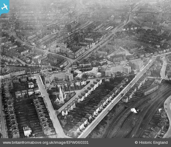
EPW060331 ENGLAND (1939). Eton Rise, Eton Hall, Eton Place and environs, Camden, 1939
© Copyright OpenStreetMap contributors and licensed by the OpenStreetMap Foundation. 2024. Cartography is licensed as CC BY-SA.
Nearby Images (33)
Details
| Title | [EPW060331] Eton Rise, Eton Hall, Eton Place and environs, Camden, 1939 |
| Reference | EPW060331 |
| Date | 11-January-1939 |
| Link | |
| Place name | CAMDEN |
| Parish | |
| District | |
| Country | ENGLAND |
| Easting / Northing | 528021, 184529 |
| Longitude / Latitude | -0.15360220615045, 51.54463761377 |
| National Grid Reference | TQ280845 |
Pins
 Class31 |
Tuesday 15th of October 2013 08:51:25 PM | |
 Class31 |
Tuesday 15th of October 2013 08:42:19 PM | |
 Class31 |
Tuesday 15th of October 2013 08:41:30 PM | |
 Class31 |
Tuesday 15th of October 2013 08:41:03 PM | |
 Class31 |
Tuesday 15th of October 2013 08:40:43 PM | |
 Class31 |
Tuesday 15th of October 2013 08:40:24 PM | |
 Class31 |
Tuesday 15th of October 2013 08:40:09 PM |


![[EPW060331] Eton Rise, Eton Hall, Eton Place and environs, Camden, 1939](http://britainfromabove.org.uk/sites/all/libraries/aerofilms-images/public/100x100/EPW/060/EPW060331.jpg)
![[EPW058477] Eton Rise, Eton Place, Prince of Wales Road and environs, Maitland Park, 1938](http://britainfromabove.org.uk/sites/all/libraries/aerofilms-images/public/100x100/EPW/058/EPW058477.jpg)
![[EPW058474] Eton Rise, Eton Place, Queen's Cresecnt and environs, Maitland Park, 1938](http://britainfromabove.org.uk/sites/all/libraries/aerofilms-images/public/100x100/EPW/058/EPW058474.jpg)
![[EPW060333] Eton Rise, Eton Hall, Eton Place and environs, Camden, 1939](http://britainfromabove.org.uk/sites/all/libraries/aerofilms-images/public/100x100/EPW/060/EPW060333.jpg)
![[EPW058473] Eton Rise, Eton Place, Prince of Wales Road and environs, Maitland Park, 1938](http://britainfromabove.org.uk/sites/all/libraries/aerofilms-images/public/100x100/EPW/058/EPW058473.jpg)
![[EPW060332] St Saviour's Church, Eton Rise, Eton Hall, Eton Place and environs, Camden, 1939](http://britainfromabove.org.uk/sites/all/libraries/aerofilms-images/public/100x100/EPW/060/EPW060332.jpg)
![[EPW058591] Eton Rise, Eton Place, Prince of Wales Road and environs, Maitland Park, 1938](http://britainfromabove.org.uk/sites/all/libraries/aerofilms-images/public/100x100/EPW/058/EPW058591.jpg)
![[EPW060302] Blocks of flats on Eton College Road (Eton Rise, Eton Hall and Eton Place), Maitland Park, 1938](http://britainfromabove.org.uk/sites/all/libraries/aerofilms-images/public/100x100/EPW/060/EPW060302.jpg)
![[EPW058476] Eton Rise, Eton Place, Prince of Wales Road and environs, Maitland Park, 1938](http://britainfromabove.org.uk/sites/all/libraries/aerofilms-images/public/100x100/EPW/058/EPW058476.jpg)
![[EPW058594] Eton Rise, Eton Place, Prince of Wales Road and environs, Maitland Park, 1938](http://britainfromabove.org.uk/sites/all/libraries/aerofilms-images/public/100x100/EPW/058/EPW058594.jpg)
![[EPW060306] Blocks of flats on Eton College Road (Eton Rise, Eton Hall and Eton Place), Maitland Park, 1938](http://britainfromabove.org.uk/sites/all/libraries/aerofilms-images/public/100x100/EPW/060/EPW060306.jpg)
![[EPW058593] Eton Rise, Eton Place, Prince of Wales Road and environs, Maitland Park, 1938](http://britainfromabove.org.uk/sites/all/libraries/aerofilms-images/public/100x100/EPW/058/EPW058593.jpg)
![[EPW060303] Blocks of flats on Eton College Road (Eton Rise, Eton Hall and Eton Place), Maitland Park, 1938](http://britainfromabove.org.uk/sites/all/libraries/aerofilms-images/public/100x100/EPW/060/EPW060303.jpg)
![[EPW058475] Eton Rise, Eton Place, Queen's Crescent and environs, Maitland Park, 1938](http://britainfromabove.org.uk/sites/all/libraries/aerofilms-images/public/100x100/EPW/058/EPW058475.jpg)
![[EPW060334] Eton Rise, Eton Hall, Eton Place, Adelaide Road and environs, Camden, 1939](http://britainfromabove.org.uk/sites/all/libraries/aerofilms-images/public/100x100/EPW/060/EPW060334.jpg)
![[EPW058478] Eton Rise, Eton Place, Queen's Crescent and environs, Maitland Park, 1938](http://britainfromabove.org.uk/sites/all/libraries/aerofilms-images/public/100x100/EPW/058/EPW058478.jpg)
![[EPW060304] Blocks of flats on Eton College Road (Eton Rise, Eton Hall and Eton Place), Maitland Park, 1938](http://britainfromabove.org.uk/sites/all/libraries/aerofilms-images/public/100x100/EPW/060/EPW060304.jpg)
![[EPW060305] Blocks of flats on Eton College Road (Eton Rise, Eton Hall and Eton Place), Maitland Park, 1938](http://britainfromabove.org.uk/sites/all/libraries/aerofilms-images/public/100x100/EPW/060/EPW060305.jpg)
![[EPW060335] St Saviour's Church, Eton Rise, Eton Hall, Eton Place and environs, Camden, 1939](http://britainfromabove.org.uk/sites/all/libraries/aerofilms-images/public/100x100/EPW/060/EPW060335.jpg)
![[EPW060330] Eton Rise, Eton Hall, Eton Place, Prince of Wales Road and environs, Camden, 1939](http://britainfromabove.org.uk/sites/all/libraries/aerofilms-images/public/100x100/EPW/060/EPW060330.jpg)
![[EPW058592] Eton Rise, Eton Place, Queen's Crescent and environs, Maitland Park, 1938](http://britainfromabove.org.uk/sites/all/libraries/aerofilms-images/public/100x100/EPW/058/EPW058592.jpg)
![[EPW056358] Eton Place Flat Block under construction, Camden Town, 1938](http://britainfromabove.org.uk/sites/all/libraries/aerofilms-images/public/100x100/EPW/056/EPW056358.jpg)
![[EPW058590] Eton Rise, Eton Place, Chalk Farm Road and environs, Maitland Park, 1938](http://britainfromabove.org.uk/sites/all/libraries/aerofilms-images/public/100x100/EPW/058/EPW058590.jpg)
![[EPW056363] Eton Place Flat Block under construction, Camden Town, 1938](http://britainfromabove.org.uk/sites/all/libraries/aerofilms-images/public/100x100/EPW/056/EPW056363.jpg)
![[EPW056365] Eton Place Flat Block under construction, Camden Town, 1938](http://britainfromabove.org.uk/sites/all/libraries/aerofilms-images/public/100x100/EPW/056/EPW056365.jpg)
![[EPW056360] Eton Rise Flat Block and St Saviour's Church, Camden Town, 1938](http://britainfromabove.org.uk/sites/all/libraries/aerofilms-images/public/100x100/EPW/056/EPW056360.jpg)
![[EPW056362] Eton Rise and Eton Place Flat Blocks and environs, Camden Town, 1938](http://britainfromabove.org.uk/sites/all/libraries/aerofilms-images/public/100x100/EPW/056/EPW056362.jpg)
![[EPW056361] Eton Rise Flat Block, Camden Town, 1938](http://britainfromabove.org.uk/sites/all/libraries/aerofilms-images/public/100x100/EPW/056/EPW056361.jpg)
![[EPW056359] Eton Place Flat Block under construction, Camden Town, 1938](http://britainfromabove.org.uk/sites/all/libraries/aerofilms-images/public/100x100/EPW/056/EPW056359.jpg)
![[EPW056364] Eton Rise Flat Block, Camden Town, 1938](http://britainfromabove.org.uk/sites/all/libraries/aerofilms-images/public/100x100/EPW/056/EPW056364.jpg)
![[EPW000808] Chapells Piano Factory and Prince of Wales Road area, Camden, 1920](http://britainfromabove.org.uk/sites/all/libraries/aerofilms-images/public/100x100/EPW/000/EPW000808.jpg)
![[EPW000807] Chapells Piano Factory and Chalk Farm Road area, Camden, 1920](http://britainfromabove.org.uk/sites/all/libraries/aerofilms-images/public/100x100/EPW/000/EPW000807.jpg)
![[EPW000806] Camden Goods Yard and Chapells Piano Factory, Camden, 1920](http://britainfromabove.org.uk/sites/all/libraries/aerofilms-images/public/100x100/EPW/000/EPW000806.jpg)


