
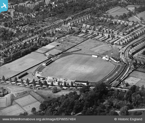
EPW057484 ENGLAND (1938). Edgbaston Cricket Ground, Edgbaston, 1938
© Copyright OpenStreetMap contributors and licensed by the OpenStreetMap Foundation. 2024. Cartography is licensed as CC BY-SA.
Nearby Images (9)
EPW057484

EAW050131
, 1953")
EAW050128
, 1953")
EAW050132
, 1953")
EAW050130
, 1953")
EAW050134
, 1953")
EAW050129
, 1953")
EAW050127
, 1953")
EAW050133
, 1953")
Details
| Title | [EPW057484] Edgbaston Cricket Ground, Edgbaston, 1938 |
| Reference | EPW057484 |
| Date | 9-June-1938 |
| Link | |
| Place name | EDGBASTON |
| Parish | |
| District | |
| Country | ENGLAND |
| Easting / Northing | 406688, 284274 |
| Longitude / Latitude | -1.9015663803756, 52.456004865312 |
| National Grid Reference | SP067843 |
Pins
 |
 Toby Clempson |
Friday 20th of January 2017 09:28:16 AM |
User Comment Contributions
 Edgbaston Cricket Ground, Edgbaston 1938 Library services at Home (Birmingham’s Home Library Service) got together with some of their visually impaired members to discuss their memories and recollections triggered by the photos from the Britain from Above project. We have also added a few facts and dates for the project. Directly in the centre of the photo is the cricket ground which originally formed part of the Calthorpe Estate. Edgbaston Road is directly underneath the cricket ground with Cannon Hill Park just visible at the bottom right hand corner of the photo. St Mary and St Ambrose Church is visible above the cricket ground and is located on the Pershore Road by the corner of Raglan Road. At the top of the photo moving left you will see some very distinctive buildings which were built in the 1930’s. These art deco style apartments are called Viceroy Close which are located on the Bristol Road. The top right corner just catches a glimpse of Calthorpe Park. Comments Betty from Hall Green recalls the art deco apartments at Viceroy Close as her friend worked as a nanny for a well to do family who lived there. Below is an audio description of the image. The narrator is Stan Hubbard. |
Helen |
Wednesday 27th of August 2014 12:43:08 PM |


