
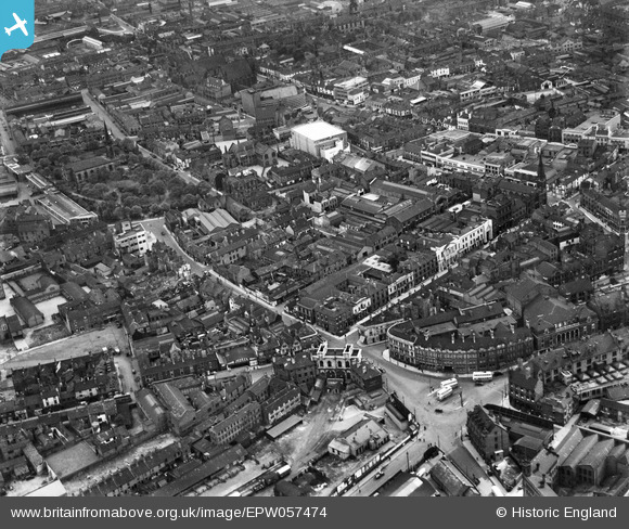
EPW057474 ENGLAND (1938). Piper's Row and the town centre, Wolverhampton, 1938
© Copyright OpenStreetMap contributors and licensed by the OpenStreetMap Foundation. 2024. Cartography is licensed as CC BY-SA.
Nearby Images (8)
EPW057474

EPW011777

EPW011780

EAW017630

EPW011798

EPW011774

EPW053731

EPW011832

Details
| Title | [EPW057474] Piper's Row and the town centre, Wolverhampton, 1938 |
| Reference | EPW057474 |
| Date | 9-June-1938 |
| Link | |
| Place name | WOLVERHAMPTON |
| Parish | |
| District | |
| Country | ENGLAND |
| Easting / Northing | 391724, 298593 |
| Longitude / Latitude | -2.1221622465339, 52.584724174122 |
| National Grid Reference | SO917986 |
Pins
 PeterD |
Monday 30th of April 2018 10:57:15 AM | |
garygareth |
Friday 6th of March 2015 03:41:02 PM | |
 bescotbeast |
Monday 22nd of September 2014 12:30:45 PM | |
WendyV |
Sunday 21st of September 2014 05:14:47 PM | |
WendyV |
Sunday 21st of September 2014 05:10:52 PM | |
WendyV |
Sunday 21st of September 2014 05:02:54 PM | |
Ragtag |
Sunday 20th of July 2014 04:42:40 PM | |
Ragtag |
Sunday 20th of July 2014 04:39:57 PM | |
Bentleyboy |
Wednesday 2nd of April 2014 12:34:42 PM | |
Bentleyboy |
Wednesday 2nd of April 2014 12:33:49 PM | |
Bentleyboy |
Wednesday 2nd of April 2014 12:31:53 PM | |
gbaddley |
Friday 8th of November 2013 11:09:36 AM |
User Comment Contributions
This was the original terminus railway station in Wolverhampton. Queens Buildings. |
Ragtag |
Sunday 20th of July 2014 04:41:09 PM |


