
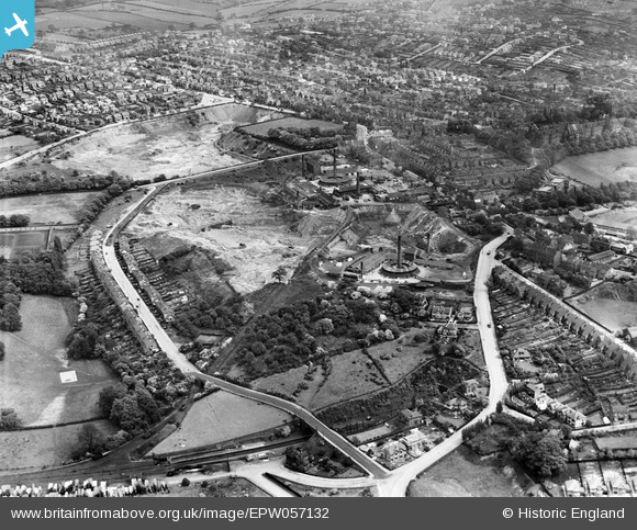
EPW057132 ENGLAND (1938). Mapperley Brick Works, Nottingham, 1938
© Copyright OpenStreetMap contributors and licensed by the OpenStreetMap Foundation. 2024. Cartography is licensed as CC BY-SA.
Nearby Images (6)
EPW057132

EPW057127

EPW057129

EPW057130

EPW057128

EPW057131

Details
| Title | [EPW057132] Mapperley Brick Works, Nottingham, 1938 |
| Reference | EPW057132 |
| Date | 20-May-1938 |
| Link | |
| Place name | NOTTINGHAM |
| Parish | |
| District | |
| Country | ENGLAND |
| Easting / Northing | 458383, 343056 |
| Longitude / Latitude | -1.1303267525784, 52.98135308526 |
| National Grid Reference | SK584431 |
Pins
 Rudy |
Sunday 3rd of May 2020 01:49:56 PM | |
NorthChurch |
Monday 27th of April 2020 01:23:27 PM | |
NorthChurch |
Friday 10th of April 2020 10:51:18 AM | |
SB146 |
Monday 25th of May 2015 08:47:09 AM | |
SB146 |
Monday 25th of May 2015 08:46:43 AM | |
SB146 |
Monday 25th of May 2015 08:46:07 AM | |
SB146 |
Monday 25th of May 2015 08:45:12 AM | |
SB146 |
Monday 25th of May 2015 08:44:19 AM | |
SB146 |
Monday 25th of May 2015 08:43:55 AM | |
SB146 |
Monday 25th of May 2015 08:43:02 AM | |
SB146 |
Monday 25th of May 2015 08:42:29 AM | |
pim-54 |
Wednesday 2nd of July 2014 02:03:45 PM | |
pim-54 |
Wednesday 2nd of July 2014 02:02:01 PM | |
pim-54 |
Wednesday 2nd of July 2014 01:53:22 PM | |
pim-54 |
Wednesday 2nd of July 2014 01:49:49 PM | |
pim-54 |
Wednesday 2nd of July 2014 01:39:04 PM | |
pim-54 |
Wednesday 2nd of July 2014 01:35:05 PM | |
pim-54 |
Wednesday 2nd of July 2014 01:34:25 PM | |
pim-54 |
Wednesday 2nd of July 2014 01:33:45 PM |


