
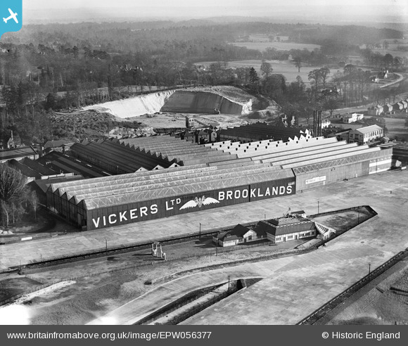
EPW056377 ENGLAND (1938). Vickers (Aviation) Ltd Works, Brooklands, 1938
© Copyright OpenStreetMap contributors and licensed by the OpenStreetMap Foundation. 2024. Cartography is licensed as CC BY-SA.
Nearby Images (19)
EPW056377
 Ltd Works, Brooklands, 1938")
EPW060343

EPW056374
 Ltd Works, Brooklands, 1938")
EPW060345

EPW016860

EPW060346

EPW060342

EPW056376
 Ltd Works, Brooklands, from the north-west, 1938")
EPW056380
 Ltd Works, Brooklands, 1938. This image has been produced from a copy-negative.")
EPW056375
 Ltd Works, Brooklands, 1938")
EPW056378
 Ltd Works, Brooklands, 1938")
EPW060349

EPW056379
 Ltd Works, Brooklands, 1938. This image has been produced from a damaged negative.")
EPW056381
 Ltd Works, Brooklands, 1938. This image has been produced from a damaged negative.")
EPW060347

EPW056382
 Ltd Works, Brooklands, 1938. This image has been produced from a damaged negative.")
EPW060344

EPW028332

EPW056383
 Ltd Works, Brooklands, 1938. This image has been produced from a damaged negative.")
Details
| Title | [EPW056377] Vickers (Aviation) Ltd Works, Brooklands, 1938 |
| Reference | EPW056377 |
| Date | 2-March-1938 |
| Link | |
| Place name | BROOKLANDS |
| Parish | |
| District | |
| Country | ENGLAND |
| Easting / Northing | 507161, 162269 |
| Longitude / Latitude | -0.46107202883119, 51.348883033878 |
| National Grid Reference | TQ072623 |
Pins
Be the first to add a comment to this image!


