
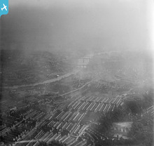
EPW054566 ENGLAND (1937). Heaton and the city centre, Newcastle upon Tyne, from the north-east, 1937

© Copyright OpenStreetMap contributors and licensed by the OpenStreetMap Foundation. 2024. Cartography is licensed as CC BY-SA.
Details
| Title | [EPW054566] Heaton and the city centre, Newcastle upon Tyne, from the north-east, 1937 |
| Reference | EPW054566 |
| Date | 30-July-1937 |
| Link | |
| Place name | NEWCASTLE UPON TYNE |
| Parish | |
| District | |
| Country | ENGLAND |
| Easting / Northing | 426571, 565160 |
| Longitude / Latitude | -1.5847863067988, 54.98025988213 |
| National Grid Reference | NZ266652 |
Pins
 avocet |
Wednesday 26th of March 2014 11:30:30 AM | |
avocet |
Wednesday 26th of March 2014 11:25:40 AM | |
avocet |
Wednesday 26th of March 2014 11:20:03 AM | |
avocet |
Wednesday 26th of March 2014 11:13:40 AM | |
avocet |
Wednesday 26th of March 2014 11:06:20 AM |
User Comment Contributions
 Older housing in Heaton |
Oldheaton |
Sunday 21st of July 2013 01:10:28 AM |


