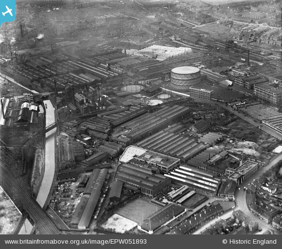
EPW051893 ENGLAND (1936). The W. and T. Avery Ltd Soho Foundry, Smethwick, 1936
© Copyright OpenStreetMap contributors and licensed by the OpenStreetMap Foundation. 2024. Cartography is licensed as CC BY-SA.
Nearby Images (33)
Details
| Title | [EPW051893] The W. and T. Avery Ltd Soho Foundry, Smethwick, 1936 |
| Reference | EPW051893 |
| Date | September-1936 |
| Link | |
| Place name | SMETHWICK |
| Parish | |
| District | |
| Country | ENGLAND |
| Easting / Northing | 403426, 288893 |
| Longitude / Latitude | -1.949528793825, 52.497564544049 |
| National Grid Reference | SP034889 |
Pins
 Rekrap |
Friday 28th of March 2014 05:46:20 PM | |
 Rekrap |
Friday 28th of March 2014 05:42:34 PM | |
 Rekrap |
Friday 28th of March 2014 05:41:04 PM | |
 Rekrap |
Friday 28th of March 2014 05:40:46 PM | |
 Rekrap |
Friday 28th of March 2014 05:40:30 PM | |
 Rekrap |
Friday 28th of March 2014 05:40:25 PM | |
 dp |
Thursday 6th of February 2014 09:50:27 PM |


![[EPW051893] The W. and T. Avery Ltd Soho Foundry, Smethwick, 1936](http://britainfromabove.org.uk/sites/all/libraries/aerofilms-images/public/100x100/EPW/051/EPW051893.jpg)
![[EPW051892] The W. and T. Avery Ltd Soho Foundry, Smethwick, 1936](http://britainfromabove.org.uk/sites/all/libraries/aerofilms-images/public/100x100/EPW/051/EPW051892.jpg)
![[EPW051890] The W. and T. Avery Ltd Soho Foundry, Smethwick, 1936](http://britainfromabove.org.uk/sites/all/libraries/aerofilms-images/public/100x100/EPW/051/EPW051890.jpg)
![[EPW051896] The W. and T. Avery Ltd Soho Foundry, Smethwick, 1936](http://britainfromabove.org.uk/sites/all/libraries/aerofilms-images/public/100x100/EPW/051/EPW051896.jpg)
![[EPW051895] The W. and T. Avery Ltd Soho Foundry, Smethwick, 1936](http://britainfromabove.org.uk/sites/all/libraries/aerofilms-images/public/100x100/EPW/051/EPW051895.jpg)
![[EPW051894] The W. and T. Avery Ltd Soho Foundry, Smethwick, 1936](http://britainfromabove.org.uk/sites/all/libraries/aerofilms-images/public/100x100/EPW/051/EPW051894.jpg)
![[EPW051891] The W. and T. Avery Ltd Soho Foundry, Smethwick, 1936](http://britainfromabove.org.uk/sites/all/libraries/aerofilms-images/public/100x100/EPW/051/EPW051891.jpg)
![[EAW001184] Merry Hill railway viaduct, Black Patch recreation ground and environs, Soho, 1946. This image has been produced from a damaged negative.](http://britainfromabove.org.uk/sites/all/libraries/aerofilms-images/public/100x100/EAW/001/EAW001184.jpg)
![[EPW053079] The George Burn Ltd City Tube and Conduit Mills on Rabone Lane, Smethwick, 1937. This image has been produced from a copy-negative.](http://britainfromabove.org.uk/sites/all/libraries/aerofilms-images/public/100x100/EPW/053/EPW053079.jpg)
![[EPW053089] The George Burn Ltd City Tube and Conduit Mills on Rabone Lane, Smethwick, 1937. This image has been produced from a damaged copy-negative.](http://britainfromabove.org.uk/sites/all/libraries/aerofilms-images/public/100x100/EPW/053/EPW053089.jpg)
![[EPW053090] The George Burn Ltd City Tube and Conduit Mills on Rabone Lane, Smethwick, 1937](http://britainfromabove.org.uk/sites/all/libraries/aerofilms-images/public/100x100/EPW/053/EPW053090.jpg)
![[EPW053080] The George Burn Ltd City Tube and Conduit Mills on Rabone Lane, Smethwick, 1937. This image has been produced from a copy-negative.](http://britainfromabove.org.uk/sites/all/libraries/aerofilms-images/public/100x100/EPW/053/EPW053080.jpg)
![[EPW053086] The George Burn Ltd City Tube and Conduit Mills on Rabone Lane, Smethwick, 1937. This image has been produced from a copy-negative.](http://britainfromabove.org.uk/sites/all/libraries/aerofilms-images/public/100x100/EPW/053/EPW053086.jpg)
![[EAW001183] Soho Railway Bridge and environs, Soho, 1946](http://britainfromabove.org.uk/sites/all/libraries/aerofilms-images/public/100x100/EAW/001/EAW001183.jpg)
![[EPW020791] Morris Commercial Cars Ltd, Soho, 1928](http://britainfromabove.org.uk/sites/all/libraries/aerofilms-images/public/100x100/EPW/020/EPW020791.jpg)
![[EPW020786] Morris Commercial Cars Ltd, Soho, 1928](http://britainfromabove.org.uk/sites/all/libraries/aerofilms-images/public/100x100/EPW/020/EPW020786.jpg)
![[EPW020790] Morris Commercial Cars Ltd, Soho, 1928](http://britainfromabove.org.uk/sites/all/libraries/aerofilms-images/public/100x100/EPW/020/EPW020790.jpg)
![[EPW020792] Morris Commercial Cars Ltd, Soho, 1928](http://britainfromabove.org.uk/sites/all/libraries/aerofilms-images/public/100x100/EPW/020/EPW020792.jpg)
![[EPW020785] Morris Commercial Cars Ltd, Soho, 1928](http://britainfromabove.org.uk/sites/all/libraries/aerofilms-images/public/100x100/EPW/020/EPW020785.jpg)
![[EPW020784] Morris Commercial Cars Ltd, Soho, 1928](http://britainfromabove.org.uk/sites/all/libraries/aerofilms-images/public/100x100/EPW/020/EPW020784.jpg)
![[EPW020788] Morris Commercial Cars Ltd, Soho, 1928](http://britainfromabove.org.uk/sites/all/libraries/aerofilms-images/public/100x100/EPW/020/EPW020788.jpg)
![[EPW020787] Morris Commercial Cars Ltd, Soho, 1928](http://britainfromabove.org.uk/sites/all/libraries/aerofilms-images/public/100x100/EPW/020/EPW020787.jpg)
![[EPW020789] Morris Commercial Cars Ltd, Soho, 1928](http://britainfromabove.org.uk/sites/all/libraries/aerofilms-images/public/100x100/EPW/020/EPW020789.jpg)
![[EPW036146] Morris Commercial Cars Ltd, Soho, 1931](http://britainfromabove.org.uk/sites/all/libraries/aerofilms-images/public/100x100/EPW/036/EPW036146.jpg)
![[EPW051897] The W. and T. Avery Ltd Soho Foundry, Smethwick, from the south-east, 1936](http://britainfromabove.org.uk/sites/all/libraries/aerofilms-images/public/100x100/EPW/051/EPW051897.jpg)
![[EPW036141] Morris Commercial Cars Ltd, Soho, 1931](http://britainfromabove.org.uk/sites/all/libraries/aerofilms-images/public/100x100/EPW/036/EPW036141.jpg)
![[EPW036145] Morris Commercial Cars Ltd, Soho, 1931](http://britainfromabove.org.uk/sites/all/libraries/aerofilms-images/public/100x100/EPW/036/EPW036145.jpg)
![[EPW036148] Morris Commercial Cars Ltd, Soho, 1931](http://britainfromabove.org.uk/sites/all/libraries/aerofilms-images/public/100x100/EPW/036/EPW036148.jpg)
![[EPW036140] Morris Commercial Cars Ltd, Soho, 1931](http://britainfromabove.org.uk/sites/all/libraries/aerofilms-images/public/100x100/EPW/036/EPW036140.jpg)
![[EAW001185] Soho Railway Bridge, Merry Hill railway viaduct, Black Patch recreation ground and environs, Soho, 1946](http://britainfromabove.org.uk/sites/all/libraries/aerofilms-images/public/100x100/EAW/001/EAW001185.jpg)
![[EPW036144] Morris Commercial Cars Ltd, Soho, 1931](http://britainfromabove.org.uk/sites/all/libraries/aerofilms-images/public/100x100/EPW/036/EPW036144.jpg)
![[EPW036143] Morris Commercial Cars Ltd, Soho, 1931](http://britainfromabove.org.uk/sites/all/libraries/aerofilms-images/public/100x100/EPW/036/EPW036143.jpg)
![[EPW036147] Morris Commercial Cars Ltd, Soho, 1931](http://britainfromabove.org.uk/sites/all/libraries/aerofilms-images/public/100x100/EPW/036/EPW036147.jpg)


