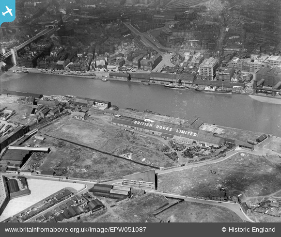
EPW051087 ENGLAND (1936). The British Ropes Ltd Wire Works, Gateshead, 1936
© Copyright OpenStreetMap contributors and licensed by the OpenStreetMap Foundation. 2024. Cartography is licensed as CC BY-SA.
Nearby Images (23)
Details
| Title | [EPW051087] The British Ropes Ltd Wire Works, Gateshead, 1936 |
| Reference | EPW051087 |
| Date | July-1936 |
| Link | |
| Place name | GATESHEAD |
| Parish | |
| District | |
| Country | ENGLAND |
| Easting / Northing | 425681, 563889 |
| Longitude / Latitude | -1.5988074553533, 54.968884034309 |
| National Grid Reference | NZ257639 |
Pins
Be the first to add a comment to this image!


![[EPW051087] The British Ropes Ltd Wire Works, Gateshead, 1936](http://britainfromabove.org.uk/sites/all/libraries/aerofilms-images/public/100x100/EPW/051/EPW051087.jpg)
![[EPW051086] The British Ropes Ltd Wire Works, Gateshead, 1936](http://britainfromabove.org.uk/sites/all/libraries/aerofilms-images/public/100x100/EPW/051/EPW051086.jpg)
![[EPW051085] The British Ropes Ltd Wire Works, Gateshead, 1936](http://britainfromabove.org.uk/sites/all/libraries/aerofilms-images/public/100x100/EPW/051/EPW051085.jpg)
![[EPW051088] The British Ropes Ltd Wire Works, Gateshead, 1936](http://britainfromabove.org.uk/sites/all/libraries/aerofilms-images/public/100x100/EPW/051/EPW051088.jpg)
![[EPW048807] The High Level Bridge, Newcastle Swing Bridge, Tyne Bridge and environs, Newcastle upon Tyne, 1935. This image has been produced from a print.](http://britainfromabove.org.uk/sites/all/libraries/aerofilms-images/public/100x100/EPW/048/EPW048807.jpg)
![[EPW051084] The British Ropes Ltd Wire Works, Gateshead, 1936](http://britainfromabove.org.uk/sites/all/libraries/aerofilms-images/public/100x100/EPW/051/EPW051084.jpg)
![[EPW051089] The British Ropes Ltd Wire Works, Gateshead, 1936](http://britainfromabove.org.uk/sites/all/libraries/aerofilms-images/public/100x100/EPW/051/EPW051089.jpg)
![[EPW051090] High Street and environs, Gateshead, from the north, 1936](http://britainfromabove.org.uk/sites/all/libraries/aerofilms-images/public/100x100/EPW/051/EPW051090.jpg)
![[EPW048801] The High Level Bridge, Newcastle Swing Bridge, Tyne Bridge and the city, Newcastle upon Tyne, 1935. This image has been produced from a print.](http://britainfromabove.org.uk/sites/all/libraries/aerofilms-images/public/100x100/EPW/048/EPW048801.jpg)
![[EAW600907] Tyne Bridge, Newcastle upon Tyne, 1991](http://britainfromabove.org.uk/sites/all/libraries/aerofilms-images/public/100x100/EAW/600/EAW600907.jpg)
![[EPW048234] Salt Meadows and environs alongside the River Tyne, Gateshead, 1935](http://britainfromabove.org.uk/sites/all/libraries/aerofilms-images/public/100x100/EPW/048/EPW048234.jpg)
![[EAW037008] The Baltic Flour Mills and British Ropes Ltd Rope Works, Gateshead, 1951. This image has been produced from a print marked by Aerofilms Ltd for photo editing.](http://britainfromabove.org.uk/sites/all/libraries/aerofilms-images/public/100x100/EAW/037/EAW037008.jpg)
![[EAW037012] The Baltic Flour Mills and British Ropes Ltd Rope Works, Gateshead, 1951. This image has been produced from a print marked by Aerofilms Ltd for photo editing.](http://britainfromabove.org.uk/sites/all/libraries/aerofilms-images/public/100x100/EAW/037/EAW037012.jpg)
![[EAW037017] The Baltic Flour Mills, Gateshead, 1951. This image has been produced from a print.](http://britainfromabove.org.uk/sites/all/libraries/aerofilms-images/public/100x100/EAW/037/EAW037017.jpg)
![[EAW037013] The Baltic Flour Mills, Gateshead, 1951. This image has been produced from a print marked by Aerofilms Ltd for photo editing.](http://britainfromabove.org.uk/sites/all/libraries/aerofilms-images/public/100x100/EAW/037/EAW037013.jpg)
![[EAW037018] The Baltic Flour Mills, Gateshead, 1951. This image has been produced from a print marked by Aerofilms Ltd for photo editing.](http://britainfromabove.org.uk/sites/all/libraries/aerofilms-images/public/100x100/EAW/037/EAW037018.jpg)
![[EAW037009] The Baltic Flour Mills, Gateshead, 1951. This image has been produced from a print marked by Aerofilms Ltd for photo editing.](http://britainfromabove.org.uk/sites/all/libraries/aerofilms-images/public/100x100/EAW/037/EAW037009.jpg)
![[EAW037010] The Baltic Flour Mills, Gateshead, 1951. This image has been produced from a print marked by Aerofilms Ltd for photo editing.](http://britainfromabove.org.uk/sites/all/libraries/aerofilms-images/public/100x100/EAW/037/EAW037010.jpg)
![[EPW048232] Salt Meadows and environs alongside the River Tyne, Gateshead, 1935](http://britainfromabove.org.uk/sites/all/libraries/aerofilms-images/public/100x100/EPW/048/EPW048232.jpg)
![[EAW037016] The Baltic Flour Mills and Quayside Goods Station, Gateshead, 1951. This image has been produced from a print marked by Aerofilms Ltd for photo editing.](http://britainfromabove.org.uk/sites/all/libraries/aerofilms-images/public/100x100/EAW/037/EAW037016.jpg)
![[EAW037014] The Baltic Flour Mills, Gateshead, 1951. This image has been produced from a print marked by Aerofilms Ltd for photo editing.](http://britainfromabove.org.uk/sites/all/libraries/aerofilms-images/public/100x100/EAW/037/EAW037014.jpg)
![[EAW037011] The Baltic Flour Mills, Gateshead, 1951. This image has been produced from a print marked by Aerofilms Ltd for photo editing.](http://britainfromabove.org.uk/sites/all/libraries/aerofilms-images/public/100x100/EAW/037/EAW037011.jpg)
![[EPW048818] Quayside Goods Station, the River Tyne and environs, Newcastle Upon Tyne, from the west, 1935](http://britainfromabove.org.uk/sites/all/libraries/aerofilms-images/public/100x100/EPW/048/EPW048818.jpg)


