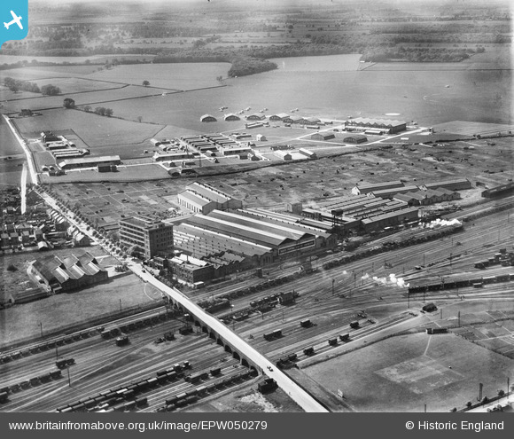
EPW050279 ENGLAND (1936). The Westwood Engineering Works and the Peterborough II (Westwood) airfield, Peterborough, 1936
© Copyright OpenStreetMap contributors and licensed by the OpenStreetMap Foundation. 2024. Cartography is licensed as CC BY-SA.
Nearby Images (24)
Details
| Title | [EPW050279] The Westwood Engineering Works and the Peterborough II (Westwood) airfield, Peterborough, 1936 |
| Reference | EPW050279 |
| Date | May-1936 |
| Link | |
| Place name | PETERBOROUGH |
| Parish | |
| District | |
| Country | ENGLAND |
| Easting / Northing | 518012, 299942 |
| Longitude / Latitude | -0.25797681394148, 52.584103104308 |
| National Grid Reference | TL180999 |


![[EPW050279] The Westwood Engineering Works and the Peterborough II (Westwood) airfield, Peterborough, 1936](http://britainfromabove.org.uk/sites/all/libraries/aerofilms-images/public/100x100/EPW/050/EPW050279.jpg)
![[EAW005684] The Baker Perkins Ltd Westwood Engineering Works, Peterborough, 1947](http://britainfromabove.org.uk/sites/all/libraries/aerofilms-images/public/100x100/EAW/005/EAW005684.jpg)
![[EPW050281] The Westwood Engineering Works and the Peterborough II (Westwood) airfield, Peterborough, 1936](http://britainfromabove.org.uk/sites/all/libraries/aerofilms-images/public/100x100/EPW/050/EPW050281.jpg)
![[EPW050274] The Westwood Engineering Works and the Peterborough II (Westwood) airfield, Peterborough, 1936](http://britainfromabove.org.uk/sites/all/libraries/aerofilms-images/public/100x100/EPW/050/EPW050274.jpg)
![[EAW005683] The Baker Perkins Ltd Westwood Engineering Works and RAF Peterborough, Peterborough, 1947. This image was marked by Aerofilms Ltd for photo editing.](http://britainfromabove.org.uk/sites/all/libraries/aerofilms-images/public/100x100/EAW/005/EAW005683.jpg)
![[EAW005685] The Baker Perkins Ltd Westwood Engineering Works, Peterborough, 1947](http://britainfromabove.org.uk/sites/all/libraries/aerofilms-images/public/100x100/EAW/005/EAW005685.jpg)
![[EPW050278] The Westwood Engineering Works and the Peterborough II (Westwood) airfield, Peterborough, 1936](http://britainfromabove.org.uk/sites/all/libraries/aerofilms-images/public/100x100/EPW/050/EPW050278.jpg)
![[EPW050275] The Westwood Engineering Works and the Peterborough II (Westwood) airfield, Peterborough, 1936](http://britainfromabove.org.uk/sites/all/libraries/aerofilms-images/public/100x100/EPW/050/EPW050275.jpg)
![[EAW005686] The Baker Perkins Ltd Westwood Engineering Works, Peterborough, 1947](http://britainfromabove.org.uk/sites/all/libraries/aerofilms-images/public/100x100/EAW/005/EAW005686.jpg)
![[EPW009768] Westwood Engineering Works, Peterborough, 1924](http://britainfromabove.org.uk/sites/all/libraries/aerofilms-images/public/100x100/EPW/009/EPW009768.jpg)
![[EPW050277] The Westwood Engineering Works alongside the Arktos Railway Sidings, Peterborough, 1936](http://britainfromabove.org.uk/sites/all/libraries/aerofilms-images/public/100x100/EPW/050/EPW050277.jpg)
![[EPW009765] Westwood Engineering Works, Peterborough, 1924](http://britainfromabove.org.uk/sites/all/libraries/aerofilms-images/public/100x100/EPW/009/EPW009765.jpg)
![[EAW005682] The Baker Perkins Ltd Westwood Engineering Works and RAF Peterborough, Peterborough, 1947. This image was marked by Aerofilms Ltd for photo editing.](http://britainfromabove.org.uk/sites/all/libraries/aerofilms-images/public/100x100/EAW/005/EAW005682.jpg)
![[EPW009770] Westwood Engineering Works, Peterborough, 1924](http://britainfromabove.org.uk/sites/all/libraries/aerofilms-images/public/100x100/EPW/009/EPW009770.jpg)
![[EPW009769] Westwood Engineering Works, Peterborough, 1924](http://britainfromabove.org.uk/sites/all/libraries/aerofilms-images/public/100x100/EPW/009/EPW009769.jpg)
![[EPW009766] Westwood Engineering Works, Peterborough, 1924](http://britainfromabove.org.uk/sites/all/libraries/aerofilms-images/public/100x100/EPW/009/EPW009766.jpg)
![[EPW016324] The Westwood Engineering Works, Peterborough, 1926](http://britainfromabove.org.uk/sites/all/libraries/aerofilms-images/public/100x100/EPW/016/EPW016324.jpg)
![[EPW009767] Westwood Engineering Works, Peterborough, 1924](http://britainfromabove.org.uk/sites/all/libraries/aerofilms-images/public/100x100/EPW/009/EPW009767.jpg)
![[EPW016323] The Westwood Engineering Works, Peterborough, 1926](http://britainfromabove.org.uk/sites/all/libraries/aerofilms-images/public/100x100/EPW/016/EPW016323.jpg)
![[EAW005677] The Baker Perkins Ltd Westwood Engineering Works and RAF Peterborough, Peterborough, from the east, 1947](http://britainfromabove.org.uk/sites/all/libraries/aerofilms-images/public/100x100/EAW/005/EAW005677.jpg)
![[EAW005681] The Baker Perkins Ltd Westwood Engineering Works and RAF Peterborough, Peterborough, from the south-east, 1947](http://britainfromabove.org.uk/sites/all/libraries/aerofilms-images/public/100x100/EAW/005/EAW005681.jpg)
![[EAW005679] The Baker Perkins Ltd Westwood Engineering Works and RAF Peterborough, Peterborough, from the south-east, 1947](http://britainfromabove.org.uk/sites/all/libraries/aerofilms-images/public/100x100/EAW/005/EAW005679.jpg)
![[EAW005678] The Baker Perkins Ltd Westwood Engineering Works and RAF Peterborough, Peterborough, from the south-east, 1947](http://britainfromabove.org.uk/sites/all/libraries/aerofilms-images/public/100x100/EAW/005/EAW005678.jpg)
![[EAW005680] The Baker Perkins Ltd Westwood Engineering Works and RAF Peterborough, Peterborough, from the east, 1947. This image was marked by Aerofilms Ltd for photo editing.](http://britainfromabove.org.uk/sites/all/libraries/aerofilms-images/public/100x100/EAW/005/EAW005680.jpg)


