
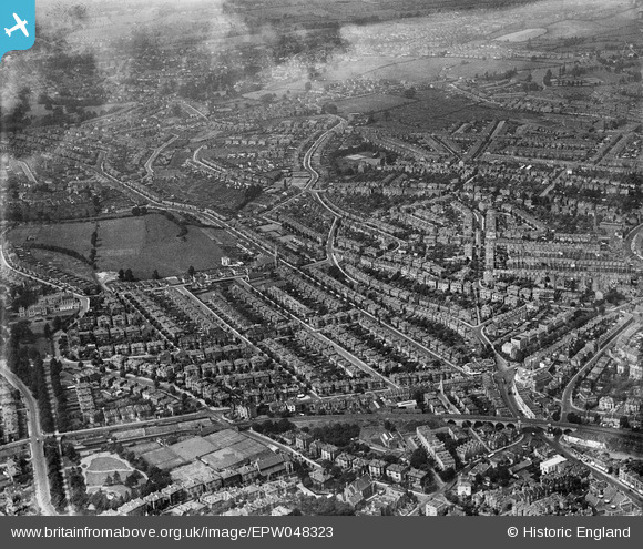
EPW048323 ENGLAND (1935). The residential area at Redland and Bishopston, Bristol, 1935
© Copyright OpenStreetMap contributors and licensed by the OpenStreetMap Foundation. 2024. Cartography is licensed as CC BY-SA.
Nearby Images (2)
EPW048323

EPW048324

Details
| Title | [EPW048323] The residential area at Redland and Bishopston, Bristol, 1935 |
| Reference | EPW048323 |
| Date | July-1935 |
| Link | |
| Place name | BRISTOL |
| Parish | |
| District | |
| Country | ENGLAND |
| Easting / Northing | 358585, 175135 |
| Longitude / Latitude | -2.5963580299103, 51.473174122645 |
| National Grid Reference | ST586751 |
Pins
 Bristolian |
Wednesday 26th of October 2022 03:21:02 PM | |
Smike47 |
Tuesday 19th of May 2020 11:48:31 AM | |
MildBunch |
Wednesday 18th of February 2015 02:07:15 PM | |
MildBunch |
Wednesday 18th of February 2015 02:06:57 PM | |
MildBunch |
Wednesday 18th of February 2015 02:06:35 PM | |
Geoff |
Tuesday 5th of August 2014 01:03:14 PM | |
Geoff |
Monday 4th of August 2014 05:28:26 PM | |
Geoff |
Monday 4th of August 2014 05:26:51 PM | |
Geoff |
Monday 4th of August 2014 05:25:06 PM | |
Geoff |
Monday 4th of August 2014 05:24:21 PM | |
Geoff |
Monday 4th of August 2014 05:22:33 PM | |
MB |
Saturday 1st of June 2013 03:19:10 PM | |
MB |
Saturday 1st of June 2013 03:18:50 PM | |
MB |
Saturday 1st of June 2013 03:18:08 PM | |
MB |
Saturday 1st of June 2013 03:16:28 PM | |
MB |
Saturday 1st of June 2013 03:16:01 PM | |
MB |
Saturday 1st of June 2013 03:15:29 PM | |
MB |
Saturday 1st of June 2013 03:14:46 PM | |
MB |
Saturday 1st of June 2013 03:14:18 PM |
User Comment Contributions
 Redland Station, 08/09/2007 |
 Class31 |
Thursday 17th of September 2015 08:50:11 PM |


