
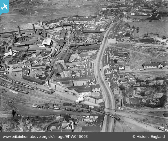
EPW046063 ENGLAND (1934). Goldbury Road and environs, West Bromwich, 1934
© Copyright OpenStreetMap contributors and licensed by the OpenStreetMap Foundation. 2024. Cartography is licensed as CC BY-SA.
Nearby Images (17)
EPW046063

EPW046064

EPW046065

EPW046062

EPW046426

EPW046066

EPW046425

EPW046424

EPW046427

EPW046067

EPW046428

EPW046429

EAW037533

EAW037539

EAW037542

EAW037538

EAW037534

Details
| Title | [EPW046063] Goldbury Road and environs, West Bromwich, 1934 |
| Reference | EPW046063 |
| Date | September-1934 |
| Link | |
| Place name | WEST BROMWICH |
| Parish | |
| District | |
| Country | ENGLAND |
| Easting / Northing | 398581, 291020 |
| Longitude / Latitude | -2.0209135272357, 52.516697244831 |
| National Grid Reference | SO986910 |
Pins
 Martin |
Tuesday 11th of February 2014 12:18:02 AM | |
Martin |
Wednesday 25th of December 2013 09:15:00 PM | |
This is possibly 22918 (1142 class) as it appears to be numbered 2291? and appears to have a low cab side sheet. BR number would be 58123 |
Dave York |
Wednesday 15th of January 2014 02:26:36 PM |
User Comment Contributions
This Oldbury Road, not Goldbury Road. To the left, off camera would be Albion Station on the ex LNWR line between Oldbury and Dudley Port. |
Steve Williams |
Monday 4th of November 2013 03:20:51 PM |


