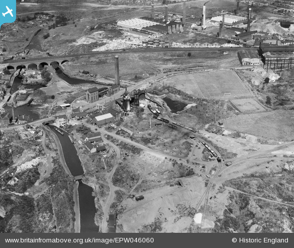
EPW046060 ENGLAND (1934). The Parkhead Viaduct, Netherton Iron Works and environs, Netherton, 1934
© Copyright OpenStreetMap contributors and licensed by the OpenStreetMap Foundation. 2024. Cartography is licensed as CC BY-SA.
Nearby Images (41)
Details
| Title | [EPW046060] The Parkhead Viaduct, Netherton Iron Works and environs, Netherton, 1934 |
| Reference | EPW046060 |
| Date | September-1934 |
| Link | |
| Place name | NETHERTON |
| Parish | |
| District | |
| Country | ENGLAND |
| Easting / Northing | 393578, 288850 |
| Longitude / Latitude | -2.0946068509523, 52.497150877057 |
| National Grid Reference | SO936889 |


![[EPW046060] The Parkhead Viaduct, Netherton Iron Works and environs, Netherton, 1934](http://britainfromabove.org.uk/sites/all/libraries/aerofilms-images/public/100x100/EPW/046/EPW046060.jpg)
![[EPW046059] The Parkhead Viaduct, Netherton Iron Works and environs, Netherton, 1934](http://britainfromabove.org.uk/sites/all/libraries/aerofilms-images/public/100x100/EPW/046/EPW046059.jpg)
![[EAW024637] Works along Peartree Lane and environs, Netherton, from the south-west, 1949. This image was marked by Aerofilms Ltd for photo editing.](http://britainfromabove.org.uk/sites/all/libraries/aerofilms-images/public/100x100/EAW/024/EAW024637.jpg)
![[EAW024633] Works along Peartree Lane looking towards Dudley, Netherton, from the south-west, 1949. This image was marked by Aerofilms Ltd for photo editing.](http://britainfromabove.org.uk/sites/all/libraries/aerofilms-images/public/100x100/EAW/024/EAW024633.jpg)
![[EPW046058] The Netherton Iron Works and environs, Netherton, 1934](http://britainfromabove.org.uk/sites/all/libraries/aerofilms-images/public/100x100/EPW/046/EPW046058.jpg)
![[EPW046056] The Parkhead Viaduct, Netherton Iron Works and environs, Netherton, 1934](http://britainfromabove.org.uk/sites/all/libraries/aerofilms-images/public/100x100/EPW/046/EPW046056.jpg)
![[EPW046055] The Parkhead Viaduct, Netherton Iron Works and environs, Netherton, 1934](http://britainfromabove.org.uk/sites/all/libraries/aerofilms-images/public/100x100/EPW/046/EPW046055.jpg)
![[EPW046061] The Netherton Iron Works and environs, Netherton, 1934](http://britainfromabove.org.uk/sites/all/libraries/aerofilms-images/public/100x100/EPW/046/EPW046061.jpg)
![[EAW000683] The Netherton Iron Works and the Parkhead Viaduct, Netherton, 1946. This image has been produced from a damaged negative.](http://britainfromabove.org.uk/sites/all/libraries/aerofilms-images/public/100x100/EAW/000/EAW000683.jpg)
![[EAW024640] M & W Grazebrook Ltd Works on Peartree Lane and environs, Netherton, from the north-west, 1949](http://britainfromabove.org.uk/sites/all/libraries/aerofilms-images/public/100x100/EAW/024/EAW024640.jpg)
![[EAW000685] The Netherton Iron Works and the surrounding area, Netherton, 1946. This image has been produced from a damaged negative.](http://britainfromabove.org.uk/sites/all/libraries/aerofilms-images/public/100x100/EAW/000/EAW000685.jpg)
![[EAW024635] M & W Grazebrook Ltd Works on Peartree Lane, Netherton, from the north-west, 1949. This image was marked by Aerofilms Ltd for photo editing.](http://britainfromabove.org.uk/sites/all/libraries/aerofilms-images/public/100x100/EAW/024/EAW024635.jpg)
![[EAW024634] M & W Grazebrook Ltd Works on Peartree Lane, Netherton, from the west, 1949. This image was marked by Aerofilms Ltd for photo editing.](http://britainfromabove.org.uk/sites/all/libraries/aerofilms-images/public/100x100/EAW/024/EAW024634.jpg)
![[EPW046057] The Netherton Iron Works and environs, Netherton, 1934](http://britainfromabove.org.uk/sites/all/libraries/aerofilms-images/public/100x100/EPW/046/EPW046057.jpg)
![[EAW000684] The Netherton Iron Works, the Parkhead Viaduct and the Thornleigh Brick Works, Netherton, from the south-east, 1946. This image has been produced from a damaged negative.](http://britainfromabove.org.uk/sites/all/libraries/aerofilms-images/public/100x100/EAW/000/EAW000684.jpg)
![[EAW000682] The Netherton Iron Works, the Parkhead Viaduct and the surrounding area, Netherton, from the south-east, 1946. This image has been produced from a damaged negative.](http://britainfromabove.org.uk/sites/all/libraries/aerofilms-images/public/100x100/EAW/000/EAW000682.jpg)
![[EAW024638] M & W Grazebrook Ltd Works on Peartree Lane and environs, Netherton, from the west, 1949. This image was marked by Aerofilms Ltd for photo editing.](http://britainfromabove.org.uk/sites/all/libraries/aerofilms-images/public/100x100/EAW/024/EAW024638.jpg)
![[EAW024636] Works along Peartree Lane and environs, Netherton, from the south, 1949. This image was marked by Aerofilms Ltd for photo editing.](http://britainfromabove.org.uk/sites/all/libraries/aerofilms-images/public/100x100/EAW/024/EAW024636.jpg)
![[EAW000686] The Netherton Iron Works and the surrounding area, Netherton, 1946. This image has been produced from a damaged negative.](http://britainfromabove.org.uk/sites/all/libraries/aerofilms-images/public/100x100/EAW/000/EAW000686.jpg)
![[EAW024639] M & W Grazebrook Ltd Works on Peartree Lane and environs, Netherton, from the north-west, 1949. This image was marked by Aerofilms Ltd for photo editing.](http://britainfromabove.org.uk/sites/all/libraries/aerofilms-images/public/100x100/EAW/024/EAW024639.jpg)
![[EAW027691] John Thompson Ltd Windmill Engineering Works and environs, Dudley, 1949. This image was marked by Aerofilms Ltd for photo editing.](http://britainfromabove.org.uk/sites/all/libraries/aerofilms-images/public/100x100/EAW/027/EAW027691.jpg)
![[EAW024641] M & W Grazebrook Ltd Works on Peartree Lane looking towards the Parkhead Viaduct and Woodside, Netherton, from the east, 1949](http://britainfromabove.org.uk/sites/all/libraries/aerofilms-images/public/100x100/EAW/024/EAW024641.jpg)
![[EAW041760] The John Thompson (Dudley) Ltd Windmill Engineering Works, Dudley, 1952. This image has been produced from a damaged negative.](http://britainfromabove.org.uk/sites/all/libraries/aerofilms-images/public/100x100/EAW/041/EAW041760.jpg)
![[EAW027698] John Thompson Ltd Windmill Engineering Works and environs, Dudley, 1949. This image has been produced from a print marked by Aerofilms Ltd for photo editing.](http://britainfromabove.org.uk/sites/all/libraries/aerofilms-images/public/100x100/EAW/027/EAW027698.jpg)
![[EAW027686] John Thompson Ltd Windmill Engineering Works and environs, Dudley, 1949. This image was marked by Aerofilms Ltd for photo editing.](http://britainfromabove.org.uk/sites/all/libraries/aerofilms-images/public/100x100/EAW/027/EAW027686.jpg)
![[EAW027696] John Thompson Ltd Windmill Engineering Works and environs, Dudley, 1949. This image has been produced from a print marked by Aerofilms Ltd for photo editing.](http://britainfromabove.org.uk/sites/all/libraries/aerofilms-images/public/100x100/EAW/027/EAW027696.jpg)
![[EAW027694] John Thompson Ltd Windmill Engineering Works and environs, Dudley, 1949. This image was marked by Aerofilms Ltd for photo editing.](http://britainfromabove.org.uk/sites/all/libraries/aerofilms-images/public/100x100/EAW/027/EAW027694.jpg)
![[EAW027697] John Thompson Ltd Windmill Engineering Works and environs, Dudley, 1949. This image has been produced from a print marked by Aerofilms Ltd for photo editing.](http://britainfromabove.org.uk/sites/all/libraries/aerofilms-images/public/100x100/EAW/027/EAW027697.jpg)
![[EAW041765] The John Thompson (Dudley) Ltd Windmill Engineering Works, Dudley, 1952. This image has been produced from a damaged negative.](http://britainfromabove.org.uk/sites/all/libraries/aerofilms-images/public/100x100/EAW/041/EAW041765.jpg)
![[EAW041766] The John Thompson (Dudley) Ltd Windmill Engineering Works, Dudley, 1952. This image has been produced from a damaged negative.](http://britainfromabove.org.uk/sites/all/libraries/aerofilms-images/public/100x100/EAW/041/EAW041766.jpg)
![[EAW027687] John Thompson Ltd Windmill Engineering Works and environs, Dudley, 1949. This image was marked by Aerofilms Ltd for photo editing.](http://britainfromabove.org.uk/sites/all/libraries/aerofilms-images/public/100x100/EAW/027/EAW027687.jpg)
![[EAW027693] John Thompson Ltd Windmill Engineering Works and environs, Dudley, 1949. This image was marked by Aerofilms Ltd for photo editing.](http://britainfromabove.org.uk/sites/all/libraries/aerofilms-images/public/100x100/EAW/027/EAW027693.jpg)
![[EAW027690] John Thompson Ltd Windmill Engineering Works and environs, Dudley, 1949. This image was marked by Aerofilms Ltd for photo editing.](http://britainfromabove.org.uk/sites/all/libraries/aerofilms-images/public/100x100/EAW/027/EAW027690.jpg)
![[EAW041762] The John Thompson (Dudley) Ltd Windmill Engineering Works, Dudley, 1952. This image has been produced from a damaged negative.](http://britainfromabove.org.uk/sites/all/libraries/aerofilms-images/public/100x100/EAW/041/EAW041762.jpg)
![[EAW027692] John Thompson Ltd Windmill Engineering Works and environs, Dudley, 1949. This image was marked by Aerofilms Ltd for photo editing.](http://britainfromabove.org.uk/sites/all/libraries/aerofilms-images/public/100x100/EAW/027/EAW027692.jpg)
![[EAW027689] John Thompson Ltd Windmill Engineering Works and environs, Dudley, 1949. This image was marked by Aerofilms Ltd for photo editing.](http://britainfromabove.org.uk/sites/all/libraries/aerofilms-images/public/100x100/EAW/027/EAW027689.jpg)
![[EAW041767] The John Thompson (Dudley) Ltd Windmill Engineering Works, Dudley, 1952. This image has been produced from a damaged negative.](http://britainfromabove.org.uk/sites/all/libraries/aerofilms-images/public/100x100/EAW/041/EAW041767.jpg)
![[EAW027688] John Thompson Ltd Windmill Engineering Works and environs, Dudley, 1949. This image was marked by Aerofilms Ltd for photo editing.](http://britainfromabove.org.uk/sites/all/libraries/aerofilms-images/public/100x100/EAW/027/EAW027688.jpg)
![[EAW027695] John Thompson Ltd Windmill Engineering Works and environs, Dudley, 1949. This image was marked by Aerofilms Ltd for photo editing.](http://britainfromabove.org.uk/sites/all/libraries/aerofilms-images/public/100x100/EAW/027/EAW027695.jpg)
![[EAW027699] John Thompson Ltd Windmill Engineering Works and environs, Dudley, 1949. This image has been produced from a print marked by Aerofilms Ltd for photo editing.](http://britainfromabove.org.uk/sites/all/libraries/aerofilms-images/public/100x100/EAW/027/EAW027699.jpg)
![[EAW041769] The John Thompson (Dudley) Ltd Windmill Engineering Works, Dudley, 1952. This image has been produced from a damaged negative.](http://britainfromabove.org.uk/sites/all/libraries/aerofilms-images/public/100x100/EAW/041/EAW041769.jpg)


