
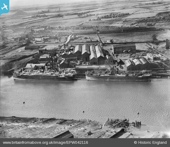
EPW042116 ENGLAND (1933). The North Eastern Marine Engineering Works, Wallsend, from the south, 1933
© Copyright OpenStreetMap contributors and licensed by the OpenStreetMap Foundation. 2024. Cartography is licensed as CC BY-SA.
Nearby Images (21)
EPW042116

EAW017401

EAW017406

EPW042115

EAW017400

EPW042118

EAW017402

EAW017410

EAW017408

EAW017403

EAW017404

EAW017397

EPW042120

EPW042117

EAW017407

EAW017405

EPW053697

EAW017409

EAW017399

EPW042119

EAW017411

Details
| Title | [EPW042116] The North Eastern Marine Engineering Works, Wallsend, from the south, 1933 |
| Reference | EPW042116 |
| Date | June-1933 |
| Link | |
| Place name | WALLSEND |
| Parish | |
| District | |
| Country | ENGLAND |
| Easting / Northing | 431409, 565964 |
| Longitude / Latitude | -1.509099638106, 54.98720382378 |
| National Grid Reference | NZ314660 |
Pins
 Rob McGinley |
Monday 31st of August 2015 09:05:38 PM | |
 his-tory |
Tuesday 29th of April 2014 12:40:39 PM | |
Geoff |
Monday 12th of August 2013 07:21:16 PM | |
Geoff |
Monday 12th of August 2013 07:19:46 PM | |
Geoff |
Monday 12th of August 2013 07:18:19 PM |


