
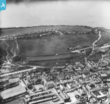
EPW042097 ENGLAND (1933). New Town and environs, Whitehaven, from the east, 1933

© Copyright OpenStreetMap contributors and licensed by the OpenStreetMap Foundation. 2024. Cartography is licensed as CC BY-SA.
Nearby Images (2)
EPW042097

EPW029185

Details
| Title | [EPW042097] New Town and environs, Whitehaven, from the east, 1933 |
| Reference | EPW042097 |
| Date | June-1933 |
| Link | |
| Place name | WHITEHAVEN |
| Parish | |
| District | |
| Country | ENGLAND |
| Easting / Northing | 297245, 517839 |
| Longitude / Latitude | -3.5886418904403, 54.545237393133 |
| National Grid Reference | NX972178 |
Pins
 lesgilpin |
Wednesday 29th of April 2015 06:34:31 PM |
User Comment Contributions
 9 |
MotoFreako64 |
Friday 14th of June 2013 08:48:23 PM |


