
EPW040896 ENGLAND (1933). The Merchant Taylors' School and environs, Moor Park, 1933

© Copyright OpenStreetMap contributors and licensed by the OpenStreetMap Foundation. 2024. Cartography is licensed as CC BY-SA.
Nearby Images (16)
EPW040896

EPW040893

EPW040891

EPW040890

EPW040892

EPW040897

EPR000494

EPW031466

EPW040899

EPW040888

EPW040895

EPW040889

EPW031285

EPR000496

EPR000495

EPW031471

Details
| Title | [EPW040896] The Merchant Taylors' School and environs, Moor Park, 1933 |
| Reference | EPW040896 |
| Date | March-1933 |
| Link | |
| Place name | MOOR PARK |
| Parish | |
| District | |
| Country | ENGLAND |
| Easting / Northing | 509058, 194068 |
| Longitude / Latitude | -0.42401263208845, 51.634367625492 |
| National Grid Reference | TQ091941 |
Pins
 John Swain |
Friday 13th of September 2013 12:08:45 PM | |
John Swain |
Friday 13th of September 2013 12:07:37 PM | |
John Swain |
Friday 13th of September 2013 12:06:30 PM | |
John Swain |
Friday 13th of September 2013 12:05:14 PM | |
John Swain |
Friday 13th of September 2013 12:03:22 PM | |
John Swain |
Friday 13th of September 2013 12:00:42 PM | |
John Swain |
Friday 13th of September 2013 11:59:28 AM | |
John Swain |
Friday 13th of September 2013 11:57:33 AM | |
John Swain |
Friday 13th of September 2013 11:56:15 AM | |
John Swain |
Friday 13th of September 2013 11:55:39 AM | |
John Swain |
Friday 13th of September 2013 11:54:56 AM | |
John Swain |
Friday 13th of September 2013 11:54:15 AM |
User Comment Contributions
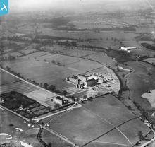 Merchant Taylors' School, Sandy Lodge, Northwood, Middlesex, was founded in 1561 and was located in the City of London (Suffolk Lane) until it moved to Charterhouse Square, Finsbury, in 1875. The need for more space led to its re-location at Sandy Lodge, a greenfield site of 256 acres, close to the Metropolitan Railway line and handily situated between Watford and Rickmansworth, on the north-west side of Greater London. This photograph was taken at the completion of the new school, which was officially opened on June 12, 1933. Between the River Colne and the LMS Rickmansworth Branch Railway line, in the right background, is the familiar white, modern (Art Deco front elevation) Asbestos Works on Tolpits Lane, which was to play a large part in the construction of Britain for the next half-century. On the right-hand margin of the picture is one of several wet-pits in the area, where the extraction of vast amounts of river gravel was used for the construction of Metroland-type suburbia, including Wembley Stadium (1923) and the British Empire Exhibition (1924/25). The early stage of the formation of Hampermill Lake (1938) is depicted here and a second feature was created by 1960. The medium-sized, independent school continues to thrive eighty years later, but the factory was closed in 1985. |
John Swain |
Monday 23rd of September 2013 10:35:16 AM |


