
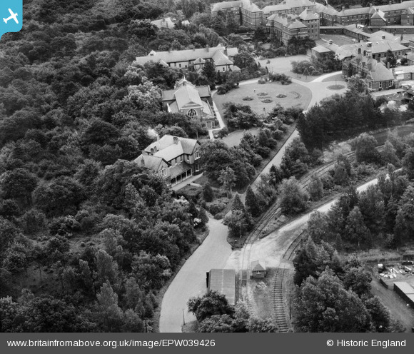
EPW039426 ENGLAND (1932). Hellingly Hospital Homestead and Church, Hellingly, 1932
© Copyright OpenStreetMap contributors and licensed by the OpenStreetMap Foundation. 2024. Cartography is licensed as CC BY-SA.
Nearby Images (5)
EPW039426

EPW039425

EPW039422

EPW039420

EPW039421

Details
| Title | [EPW039426] Hellingly Hospital Homestead and Church, Hellingly, 1932 |
| Reference | EPW039426 |
| Date | August-1932 |
| Link | |
| Place name | HELLINGLY |
| Parish | HELLINGLY |
| District | |
| Country | ENGLAND |
| Easting / Northing | 559612, 112569 |
| Longitude / Latitude | 0.26963551282506, 50.889969748486 |
| National Grid Reference | TQ596126 |
Pins
 Phil Parker |
Saturday 30th of December 2017 09:49:48 AM | |
 Dan Gregory |
Wednesday 4th of June 2014 03:48:05 PM | |
Dan Gregory |
Wednesday 4th of June 2014 03:15:31 PM | |
Dan Gregory |
Wednesday 4th of June 2014 03:15:04 PM | |
Dan Gregory |
Wednesday 4th of June 2014 03:14:42 PM | |
Dan Gregory |
Wednesday 4th of June 2014 03:14:12 PM |
User Comment Contributions
 East Sussex County Asylum - Hellingly Hospital. Compact Arrow plan buildings by G.T. Hine, 1898-1903. Detail: Chapel, Administration and hospital electric railway. Further reading: http://thetimechamber.co.uk/beta/sites/asylums/east-sussex-county-asylum-hellingly |
Dan Gregory |
Wednesday 4th of June 2014 03:52:45 PM |


