
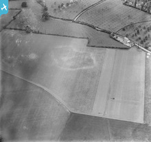
EPW038356 ENGLAND (1932). A cropmark near Poplar Gate, Leonard Stanley, 1932. This image has been produced from a damaged negative.

© Copyright OpenStreetMap contributors and licensed by the OpenStreetMap Foundation. 2024. Cartography is licensed as CC BY-SA.
Nearby Images (2)
EPW038356

EPW038355

Details
| Title | [EPW038356] A cropmark near Poplar Gate, Leonard Stanley, 1932. This image has been produced from a damaged negative. |
| Reference | EPW038356 |
| Date | June-1932 |
| Link | |
| Place name | LEONARD STANLEY |
| Parish | LEONARD STANLEY |
| District | |
| Country | ENGLAND |
| Easting / Northing | 379569, 203983 |
| Longitude / Latitude | -2.2958853102616, 51.733729185041 |
| National Grid Reference | SO796040 |
Pins
 Aeia |
Thursday 21st of July 2022 01:38:53 PM | |
 Class31 |
Sunday 27th of October 2013 07:36:36 PM | |
kent2 |
Friday 25th of October 2013 08:04:20 AM | |
bugbear |
Friday 30th of August 2013 05:13:10 PM | |
Bob Hayes |
Friday 23rd of August 2013 02:04:27 PM | |
shunter |
Tuesday 2nd of July 2013 09:08:07 PM | |
Biggles1951 |
Friday 14th of June 2013 04:13:12 PM | |
TheBlueCube |
Wednesday 23rd of January 2013 07:38:05 PM |
User Comment Contributions
the OS map of 1938 shows this to be poplar gate, leonard Stanley |
c |
Friday 1st of November 2013 03:45:26 PM |
Well done again c. How did you find this location? |
Class31 |
Sunday 27th of October 2013 07:34:50 PM |
Fantastic "spot" c, well done. We'll update the catalogue with the new information and post the updated record here in due course. Yours, Katy Britain from Above Cataloguing Team Leader |
Katy Whitaker |
Friday 1st of November 2013 03:45:26 PM |
View looking north. |
Class31 |
Sunday 27th of October 2013 07:37:47 PM |
Same features shown as on EPW038355. I wonder if this is somewhere between Gloucester (EPW038354 taken there) and Bath (EPW038357 taken there). |
Rebecca |
Monday 15th of July 2013 04:59:23 PM |
Long way between those two places. More likely to be around one or the other? |
Dave T |
Monday 15th of July 2013 04:59:23 PM |
 Possible archaeological crop marks on this as yet unlocated photo. Already put forward by "Rebecca", but without the image included. |
David Parry |
Sunday 10th of March 2013 05:32:46 PM |
It is interesting that there are 'lattice-work' 4 pylons in this picture. 2 highlighted to the right of the house & 2 more spaced apart at the top of the field to the left of the house. There are no obvious cables associated with them. |
TheBlueCube |
Wednesday 23rd of January 2013 07:40:43 PM |
Archaeological crop or soil mark. Orchards in background. |
Rebecca |
Wednesday 9th of January 2013 05:21:03 PM |


