
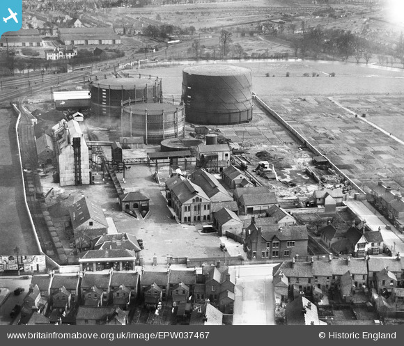
EPW037467 ENGLAND (1932). The Bedford Gas Works, Bedford, 1932
© Copyright OpenStreetMap contributors and licensed by the OpenStreetMap Foundation. 2024. Cartography is licensed as CC BY-SA.
Nearby Images (10)
EPW037467

EPW037468

EPW037469

EPW037462

EPW037465

EPW037470

EPW037464

EPW037463

EPW037466

EPW035881

Details
| Title | [EPW037467] The Bedford Gas Works, Bedford, 1932 |
| Reference | EPW037467 |
| Date | April-1932 |
| Link | |
| Place name | BEDFORD |
| Parish | |
| District | |
| Country | ENGLAND |
| Easting / Northing | 504090, 249306 |
| Longitude / Latitude | -0.47910906276624, 52.131831428259 |
| National Grid Reference | TL041493 |
Pins
 melgibbs |
Thursday 14th of January 2016 04:24:43 PM | |
melgibbs |
Thursday 1st of May 2014 05:53:42 PM | |
melgibbs |
Tuesday 14th of January 2014 08:11:45 PM | |
melgibbs |
Tuesday 14th of January 2014 08:10:58 PM | |
melgibbs |
Tuesday 14th of January 2014 08:10:18 PM | |
melgibbs |
Tuesday 14th of January 2014 08:09:54 PM | |
melgibbs |
Tuesday 14th of January 2014 08:09:26 PM | |
 Class31 |
Sunday 17th of February 2013 03:44:30 PM | |
 MB |
Wednesday 6th of February 2013 11:05:00 AM | |
MB |
Wednesday 6th of February 2013 11:04:23 AM |


