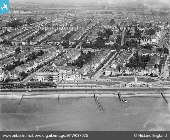
EPW037025 ENGLAND (1931). The Western Esplanade, Manor Road and environs, Westcliff-on-Sea, 1931
© Copyright OpenStreetMap contributors and licensed by the OpenStreetMap Foundation. 2024. Cartography is licensed as CC BY-SA.
Nearby Images (17)
Details
| Title | [EPW037025] The Western Esplanade, Manor Road and environs, Westcliff-on-Sea, 1931 |
| Reference | EPW037025 |
| Date | October-1931 |
| Link | |
| Place name | WESTCLIFF-ON-SEA |
| Parish | |
| District | |
| Country | ENGLAND |
| Easting / Northing | 586580, 185237 |
| Longitude / Latitude | 0.69050236329851, 51.534677923921 |
| National Grid Reference | TQ866852 |
Pins
Be the first to add a comment to this image!


![[EPW037025] The Western Esplanade, Manor Road and environs, Westcliff-on-Sea, 1931](http://britainfromabove.org.uk/sites/all/libraries/aerofilms-images/public/100x100/EPW/037/EPW037025.jpg)
![[EAW053092] The Overcliff Hotel and Palmerston Road, Southend-on-Sea, from the south, 1954](http://britainfromabove.org.uk/sites/all/libraries/aerofilms-images/public/100x100/EAW/053/EAW053092.jpg)
![[EPW054668] Argyll House, the Western Esplanade, Clifton Drive and the town, Westcliff-on-Sea, from the south-west, 1937](http://britainfromabove.org.uk/sites/all/libraries/aerofilms-images/public/100x100/EPW/054/EPW054668.jpg)
![[EPW040969] The Western Esplanade and the town alongside the seafront, Southend-on-Sea, from the south-east, 1933](http://britainfromabove.org.uk/sites/all/libraries/aerofilms-images/public/100x100/EPW/040/EPW040969.jpg)
![[EPW037021] The Western Esplanade, Clifton Drive and environs, Westcliff-on-Sea, from the south-west, 1931](http://britainfromabove.org.uk/sites/all/libraries/aerofilms-images/public/100x100/EPW/037/EPW037021.jpg)
![[EPW037023] The Western Esplanade, Palmerston Road and environs, Westcliff-on-Sea, 1931](http://britainfromabove.org.uk/sites/all/libraries/aerofilms-images/public/100x100/EPW/037/EPW037023.jpg)
![[EPW037022] The Westcliff Jetty, Pembury Road and environs, Westcliff-on-Sea, from the south, 1931](http://britainfromabove.org.uk/sites/all/libraries/aerofilms-images/public/100x100/EPW/037/EPW037022.jpg)
![[EPW036732] The Western Esplanade and housing surrounding Pembury Road and Palmerston Road, Southend-on-Sea, 1931](http://britainfromabove.org.uk/sites/all/libraries/aerofilms-images/public/100x100/EPW/036/EPW036732.jpg)
![[EAW043707] Western Esplanade, Westcliff-on-Sea, 1952](http://britainfromabove.org.uk/sites/all/libraries/aerofilms-images/public/100x100/EAW/043/EAW043707.jpg)
![[EPW040985] The Western Esplanade, the seafront and Westcliff-on-Sea, Southend-on-Sea, from the south-east, 1933](http://britainfromabove.org.uk/sites/all/libraries/aerofilms-images/public/100x100/EPW/040/EPW040985.jpg)
![[EAW053101] Argyll House, Southend-on-Sea, 1954](http://britainfromabove.org.uk/sites/all/libraries/aerofilms-images/public/100x100/EAW/053/EAW053101.jpg)
![[EPW036996] The Western Esplanade, Holland Road, and environs, Westcliff-on-Sea, from the south-west, 1931](http://britainfromabove.org.uk/sites/all/libraries/aerofilms-images/public/100x100/EPW/036/EPW036996.jpg)
![[EPW000543] Westcliff-on-Sea, Southend-on-Sea, 1920](http://britainfromabove.org.uk/sites/all/libraries/aerofilms-images/public/100x100/EPW/000/EPW000543.jpg)
![[EPW058502] Clifton Drive and environs, Westcliff-on-Sea, 1938](http://britainfromabove.org.uk/sites/all/libraries/aerofilms-images/public/100x100/EPW/058/EPW058502.jpg)
![[EPW024884] Westcliff Jetty and the town, Westcliff-on-Sea, 1928](http://britainfromabove.org.uk/sites/all/libraries/aerofilms-images/public/100x100/EPW/024/EPW024884.jpg)
![[EAW053103] Westcliff Jetty and the Mount Liell Hotel, Southend-on-Sea, 1954](http://britainfromabove.org.uk/sites/all/libraries/aerofilms-images/public/100x100/EAW/053/EAW053103.jpg)
![[EPW016560] The Esplanade and surrounding housing around Leonard Road and environs, Westcliff-on-Sea, 1926](http://britainfromabove.org.uk/sites/all/libraries/aerofilms-images/public/100x100/EPW/016/EPW016560.jpg)


