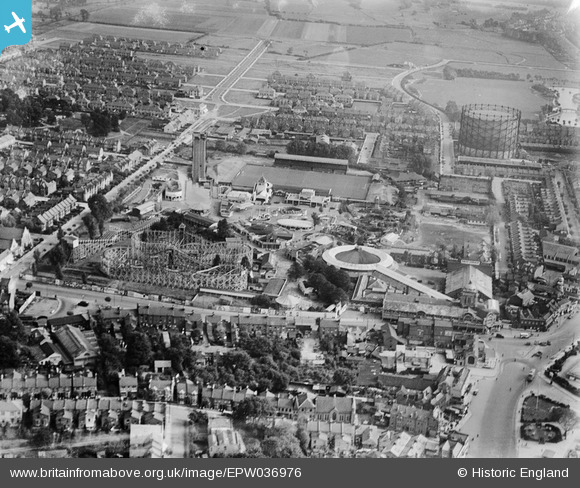
EPW036976 ENGLAND (1931). The Kursaal, Southend-on-Sea, 1931
© Copyright OpenStreetMap contributors and licensed by the OpenStreetMap Foundation. 2024. Cartography is licensed as CC BY-SA.
Nearby Images (48)
Details
| Title | [EPW036976] The Kursaal, Southend-on-Sea, 1931 |
| Reference | EPW036976 |
| Date | October-1931 |
| Link | |
| Place name | SOUTHEND-ON-SEA |
| Parish | |
| District | |
| Country | ENGLAND |
| Easting / Northing | 589185, 185213 |
| Longitude / Latitude | 0.7280083342524, 51.533595380588 |
| National Grid Reference | TQ892852 |
Pins
Be the first to add a comment to this image!


![[EPW036976] The Kursaal, Southend-on-Sea, 1931](http://britainfromabove.org.uk/sites/all/libraries/aerofilms-images/public/100x100/EPW/036/EPW036976.jpg)
![[EPW058223] The Kursaal, Southend-on-Sea, 1938](http://britainfromabove.org.uk/sites/all/libraries/aerofilms-images/public/100x100/EPW/058/EPW058223.jpg)
![[EPW058443] The Kursaal, Southend-on-Sea, 1938](http://britainfromabove.org.uk/sites/all/libraries/aerofilms-images/public/100x100/EPW/058/EPW058443.jpg)
![[EPW036617] The Kursaal, Southend-on-Sea, 1931](http://britainfromabove.org.uk/sites/all/libraries/aerofilms-images/public/100x100/EPW/036/EPW036617.jpg)
![[EPW036614] The Kursaal, Southend-on-Sea, 1931](http://britainfromabove.org.uk/sites/all/libraries/aerofilms-images/public/100x100/EPW/036/EPW036614.jpg)
![[EPW058225] The Kursaal and the surrounding residential area, Southend-on-Sea, 1938](http://britainfromabove.org.uk/sites/all/libraries/aerofilms-images/public/100x100/EPW/058/EPW058225.jpg)
![[EPW062747] The Kursaal, Southend-on-Sea, 1939](http://britainfromabove.org.uk/sites/all/libraries/aerofilms-images/public/100x100/EPW/062/EPW062747.jpg)
![[EPW039862] The Kursaal Zoo and Amusement Park, Southend-on-Sea, 1932. This image has been produced from a damaged negative.](http://britainfromabove.org.uk/sites/all/libraries/aerofilms-images/public/100x100/EPW/039/EPW039862.jpg)
![[EPW058447] The Kursaal, Southend-on-Sea, 1938](http://britainfromabove.org.uk/sites/all/libraries/aerofilms-images/public/100x100/EPW/058/EPW058447.jpg)
![[EPW032923] The Kursaal, Southend-on-Sea, 1930](http://britainfromabove.org.uk/sites/all/libraries/aerofilms-images/public/100x100/EPW/032/EPW032923.jpg)
![[EPW039861] The Kursaal Zoo and Amusement Park, Southend-on-Sea, 1932](http://britainfromabove.org.uk/sites/all/libraries/aerofilms-images/public/100x100/EPW/039/EPW039861.jpg)
![[EPW058446] The Kursaal, Southend-on-Sea, 1938](http://britainfromabove.org.uk/sites/all/libraries/aerofilms-images/public/100x100/EPW/058/EPW058446.jpg)
![[EPW036980] The Kursaal, Southend-on-Sea, 1931](http://britainfromabove.org.uk/sites/all/libraries/aerofilms-images/public/100x100/EPW/036/EPW036980.jpg)
![[EPW036616] The Kursaal, Southend-on-Sea, 1931](http://britainfromabove.org.uk/sites/all/libraries/aerofilms-images/public/100x100/EPW/036/EPW036616.jpg)
![[EPW036977] The Kursaal, Southend-on-Sea, 1931](http://britainfromabove.org.uk/sites/all/libraries/aerofilms-images/public/100x100/EPW/036/EPW036977.jpg)
![[EPW039864] The Kursaal Zoo and Amusement Park, Southend-on-Sea, 1932](http://britainfromabove.org.uk/sites/all/libraries/aerofilms-images/public/100x100/EPW/039/EPW039864.jpg)
![[EPW032924] The Kursaal, Southend-on-Sea, 1930](http://britainfromabove.org.uk/sites/all/libraries/aerofilms-images/public/100x100/EPW/032/EPW032924.jpg)
![[EPW062744] The Kursaal, Southend-on-Sea, 1939](http://britainfromabove.org.uk/sites/all/libraries/aerofilms-images/public/100x100/EPW/062/EPW062744.jpg)
![[EPW058445] The Kursaal, Southend-on-Sea, 1938](http://britainfromabove.org.uk/sites/all/libraries/aerofilms-images/public/100x100/EPW/058/EPW058445.jpg)
![[EPW032921] The Kursaal and environs, Southend-on-Sea, 1930](http://britainfromabove.org.uk/sites/all/libraries/aerofilms-images/public/100x100/EPW/032/EPW032921.jpg)
![[EPW036981] The Kursaal, Southend-on-Sea, 1931](http://britainfromabove.org.uk/sites/all/libraries/aerofilms-images/public/100x100/EPW/036/EPW036981.jpg)
![[EPW062743] The Kursaal, Southend-on-Sea, 1939. This image has been affected by flare.](http://britainfromabove.org.uk/sites/all/libraries/aerofilms-images/public/100x100/EPW/062/EPW062743.jpg)
![[EPW036615] The Kursaal, Southend-on-Sea, 1931](http://britainfromabove.org.uk/sites/all/libraries/aerofilms-images/public/100x100/EPW/036/EPW036615.jpg)
![[EPW058444] The Kursaal, Southend-on-Sea, 1938](http://britainfromabove.org.uk/sites/all/libraries/aerofilms-images/public/100x100/EPW/058/EPW058444.jpg)
![[EPW036978] The Kursaal, Southend-on-Sea, 1931](http://britainfromabove.org.uk/sites/all/libraries/aerofilms-images/public/100x100/EPW/036/EPW036978.jpg)
![[EAW024659] The Kursaal and town, Southend-on-Sea, from the east, 1949](http://britainfromabove.org.uk/sites/all/libraries/aerofilms-images/public/100x100/EAW/024/EAW024659.jpg)
![[EPW032919] The Kursaal, Southend-on-Sea, 1930](http://britainfromabove.org.uk/sites/all/libraries/aerofilms-images/public/100x100/EPW/032/EPW032919.jpg)
![[EPW032925] The Kursaal, Southend-on-Sea, 1930](http://britainfromabove.org.uk/sites/all/libraries/aerofilms-images/public/100x100/EPW/032/EPW032925.jpg)
![[EAW002194] The Kursaal and environs, Southend-on-Sea, 1946](http://britainfromabove.org.uk/sites/all/libraries/aerofilms-images/public/100x100/EAW/002/EAW002194.jpg)
![[EPW039865] The Kursaal Zoo and Amusement Park, Southend-on-Sea, 1932](http://britainfromabove.org.uk/sites/all/libraries/aerofilms-images/public/100x100/EPW/039/EPW039865.jpg)
![[EPW032920] The Kursaal and environs, Southend-on-Sea, 1930](http://britainfromabove.org.uk/sites/all/libraries/aerofilms-images/public/100x100/EPW/032/EPW032920.jpg)
![[EPW024869] The Kursaal, Southend-on-Sea, 1928](http://britainfromabove.org.uk/sites/all/libraries/aerofilms-images/public/100x100/EPW/024/EPW024869.jpg)
![[EPW036612] The Kursaal, Southend-on-Sea, 1931](http://britainfromabove.org.uk/sites/all/libraries/aerofilms-images/public/100x100/EPW/036/EPW036612.jpg)
![[EPW040987] The Kursaal Zoo and Amusement Park, Southend-on-Sea, 1933](http://britainfromabove.org.uk/sites/all/libraries/aerofilms-images/public/100x100/EPW/040/EPW040987.jpg)
![[EAW024661] The Kursaal and environs, Southend-on-Sea, 1949](http://britainfromabove.org.uk/sites/all/libraries/aerofilms-images/public/100x100/EAW/024/EAW024661.jpg)
![[EAW002191] The Kursaal and environs, Southend-on-Sea, 1946](http://britainfromabove.org.uk/sites/all/libraries/aerofilms-images/public/100x100/EAW/002/EAW002191.jpg)
![[EAW002192] The Kursaal and sea front, Southend-on-Sea, 1946](http://britainfromabove.org.uk/sites/all/libraries/aerofilms-images/public/100x100/EAW/002/EAW002192.jpg)
![[EPW036726] The Eastern Esplanade, the Kursaal Zoo and Amusement Park and environs, Southend-on-Sea, 1931](http://britainfromabove.org.uk/sites/all/libraries/aerofilms-images/public/100x100/EPW/036/EPW036726.jpg)
![[EPW062745] The Kursaal with Southend Pier in the distance, Southend-on-Sea, 1939](http://britainfromabove.org.uk/sites/all/libraries/aerofilms-images/public/100x100/EPW/062/EPW062745.jpg)
![[EPW000444] Kursaal, Southend-on-Sea, 1920](http://britainfromabove.org.uk/sites/all/libraries/aerofilms-images/public/100x100/EPW/000/EPW000444.jpg)
![[EPW000443] Kursaal, Southend-on-Sea, 1920](http://britainfromabove.org.uk/sites/all/libraries/aerofilms-images/public/100x100/EPW/000/EPW000443.jpg)
![[EPW024890] The Kursaal and Marine Parade, Southend-on-Sea, 1928](http://britainfromabove.org.uk/sites/all/libraries/aerofilms-images/public/100x100/EPW/024/EPW024890.jpg)
![[EPW010871] Pleasant Road, Southchurch Avenue and the Kursaal, Southend-on-Sea, 1924. This image has been produced from a copy-negative.](http://britainfromabove.org.uk/sites/all/libraries/aerofilms-images/public/100x100/EPW/010/EPW010871.jpg)
![[EPW036730] The Kursaal Zoo and Amusement Park alongside the Eastern Esplanade and seafront, Southend-on-Sea, 1931](http://britainfromabove.org.uk/sites/all/libraries/aerofilms-images/public/100x100/EPW/036/EPW036730.jpg)
![[EPW058224] The Kursaal, Southend-on-Sea, from the south-west, 1938](http://britainfromabove.org.uk/sites/all/libraries/aerofilms-images/public/100x100/EPW/058/EPW058224.jpg)
![[EAW024660] The waterfront and town from Corporation Landing Pier to The Shrubbery and beyond, Southend-on-Sea, from the east, 1949](http://britainfromabove.org.uk/sites/all/libraries/aerofilms-images/public/100x100/EAW/024/EAW024660.jpg)
![[EPW058226] The Kursaal, Southend-on-Sea, from the south-west, 1938](http://britainfromabove.org.uk/sites/all/libraries/aerofilms-images/public/100x100/EPW/058/EPW058226.jpg)
![[EPW058222] The Kursaal, Southend-on-Sea, from the south-west, 1938](http://britainfromabove.org.uk/sites/all/libraries/aerofilms-images/public/100x100/EPW/058/EPW058222.jpg)


